Why a feverish Pacific could weaken India's next monsoon
Forecasters say a strong El Nino is likely to return by late 2026, and India's weather office is already warning of a below-normal monsoon for hundreds of millions of farmers.
The world's oceans have been running a low-grade fever for two years, and the Pacific is about to spike again.
On May 14, the United States' National Oceanic and Atmospheric Administration raised the odds that El Nino, the Pacific's recurring warm phase, will arrive by July to 82 per cent, with a two-thirds chance of turning strong or very strong by the year's end. There is now roughly an even chance it will become a "super" El Nino, the kind that can raise ocean temperatures more than 2°C above normal.
El Nino is not the weather. It is a symptom. Every few years, the tropical Pacific sheds a vast store of heat. The released energy reshuffles rain and drought across the planet.
For India, where irrigation reaches only about 55 per cent of the cropped area — and the rest leans on the June-to-September monsoon, according to the Economic Survey 2024–25 — the question is no longer whether the ocean is warming; it's how hard the next wave will land on the fields.
IT COMES IN WAVES
Picture the Pacific Ocean as a patient whose temperature charts in cycles. Nino 3.4, the patch of ocean that scientists watch most closely, reached 2.03°C above normal during the record "super" El Nino of 2023–24. It then cooled to 0.7°C below normal by November 2025, before climbing again to 0.24°C above normal this April, according to the NOAA. Each swing has grown sharper since the 1960s.
THE WHOLE OCEAN IS WARM NOW
This time, the fever starts from a higher baseline. April 2026 was the second-warmest April for the global ocean on record, 0.5°C above the 1991–2020 average and behind only April 2024, according to the European Union's Copernicus climate service. A returning El Nino now builds on heat that never fully drained away.
INDIA'S MONSOON ON A KNIFE'S EDGE
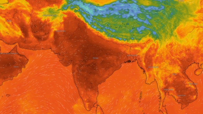
The monsoon is India's circulatory system, and El Nino tends to constrict it. On April 13, the India Meteorological Department released its long-range forecast, placing the south-west monsoon at below-normal at 92 per cent of the long-period average, citing possible El Nino conditions during the season.
The IMD set the chance of a deficient season at 35 per cent and a below-normal one at 31 per cent, against 27 per cent for a normal year. It will update the outlook in the last week of May, so today's figure is the first word, not the last.
PAST EL NINOS LEFT A CROP SCAR
The risk is not abstract for India's kharif season. A 2023 study led by N Subash and colleagues at the Indian Council of Agricultural Research's Indian Institute of Farming Systems Research analysed district-wise yields of four monsoon crops, rice, maize, pearl millet, and sorghum, across the El Nino years of 2002, 2004 and 2009. It classified a district as highly vulnerable when a crop's yield was more than 10 per cent below the average of the previous and following years. Rice was the worst-affected, with 77 districts in that category, against 65 for maize and 36 for sorghum. The authors said this district-level mapping should feed short-term and long-term contingency planning, from improved crop varieties to timely irrigation and stronger extension advisories, whenever an El Nino is forecast.
BODY HAD DEFENCES
The link is a tendency, not a verdict. El Nino is associated with weaker Indian monsoons, yet not every El Nino year has been dry. The IMD also expects a positive Indian Ocean Dipole, a warm patch of sea off East Africa that often pulls extra moisture towards India, and below-normal Eurasian snow this winter, another pattern historically linked to better rains. Forecasters still see a one-in-three chance El Nino stays moderate.
WHAT A THIN MONSOON WOULD MEAN
A weak monsoon does not stay in the sky. Months later, it surfaces in the kharif sowing figures, then in food prices and reservoir levels. With nearly half the cropped area unirrigated and leaning on the rain, the gap between a normal monsoon and one at 92 per cent is the difference between a comfortable harvest and a strained one for tens of millions of households.
READING THE CHART, NOT THE CALENDAR
The human body fights a fever to protect itself. The planet runs one because it is overheating, and the spikes are arriving closer together. The Pacific's next fever will pass, as they all do. The harder question is what India plants, stores, and prices in the months before it breaks.
The world's oceans have been running a low-grade fever for two years, and the Pacific is about to spike again.
On May 14, the United States' National Oceanic and Atmospheric Administration raised the odds that El Nino, the Pacific's recurring warm phase, will arrive by July to 82 per cent, with a two-thirds chance of turning strong or very strong by the year's end. There is now roughly an even chance it will become a "super" El Nino, the kind that can raise ocean temperatures more than 2°C above normal.
El Nino is not the weather. It is a symptom. Every few years, the tropical Pacific sheds a vast store of heat. The released energy reshuffles rain and drought across the planet.
For India, where irrigation reaches only about 55 per cent of the cropped area — and the rest leans on the June-to-September monsoon, according to the Economic Survey 2024–25 — the question is no longer whether the ocean is warming; it's how hard the next wave will land on the fields.
IT COMES IN WAVES
Picture the Pacific Ocean as a patient whose temperature charts in cycles. Nino 3.4, the patch of ocean that scientists watch most closely, reached 2.03°C above normal during the record "super" El Nino of 2023–24. It then cooled to 0.7°C below normal by November 2025, before climbing again to 0.24°C above normal this April, according to the NOAA. Each swing has grown sharper since the 1960s.
THE WHOLE OCEAN IS WARM NOW
This time, the fever starts from a higher baseline. April 2026 was the second-warmest April for the global ocean on record, 0.5°C above the 1991–2020 average and behind only April 2024, according to the European Union's Copernicus climate service. A returning El Nino now builds on heat that never fully drained away.
INDIA'S MONSOON ON A KNIFE'S EDGE
The monsoon is India's circulatory system, and El Nino tends to constrict it. On April 13, the India Meteorological Department released its long-range forecast, placing the south-west monsoon at below-normal at 92 per cent of the long-period average, citing possible El Nino conditions during the season.
The IMD set the chance of a deficient season at 35 per cent and a below-normal one at 31 per cent, against 27 per cent for a normal year. It will update the outlook in the last week of May, so today's figure is the first word, not the last.
PAST EL NINOS LEFT A CROP SCAR
The risk is not abstract for India's kharif season. A 2023 study led by N Subash and colleagues at the Indian Council of Agricultural Research's Indian Institute of Farming Systems Research analysed district-wise yields of four monsoon crops, rice, maize, pearl millet, and sorghum, across the El Nino years of 2002, 2004 and 2009. It classified a district as highly vulnerable when a crop's yield was more than 10 per cent below the average of the previous and following years. Rice was the worst-affected, with 77 districts in that category, against 65 for maize and 36 for sorghum. The authors said this district-level mapping should feed short-term and long-term contingency planning, from improved crop varieties to timely irrigation and stronger extension advisories, whenever an El Nino is forecast.
BODY HAD DEFENCES
The link is a tendency, not a verdict. El Nino is associated with weaker Indian monsoons, yet not every El Nino year has been dry. The IMD also expects a positive Indian Ocean Dipole, a warm patch of sea off East Africa that often pulls extra moisture towards India, and below-normal Eurasian snow this winter, another pattern historically linked to better rains. Forecasters still see a one-in-three chance El Nino stays moderate.
WHAT A THIN MONSOON WOULD MEAN
A weak monsoon does not stay in the sky. Months later, it surfaces in the kharif sowing figures, then in food prices and reservoir levels. With nearly half the cropped area unirrigated and leaning on the rain, the gap between a normal monsoon and one at 92 per cent is the difference between a comfortable harvest and a strained one for tens of millions of households.
READING THE CHART, NOT THE CALENDAR
The human body fights a fever to protect itself. The planet runs one because it is overheating, and the spikes are arriving closer together. The Pacific's next fever will pass, as they all do. The harder question is what India plants, stores, and prices in the months before it breaks.