India's driest June in over a century puts kharif season at risk
A year after early rains lifted planting, the 2026 monsoon has opened about a third below normal, leaving all nine major kharif states short of rain just as sowing should be gathering pace.
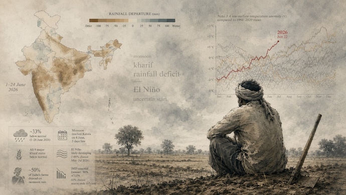
The monsoon has had a halting start. Through June 24, India had received about a third less rain than normal, according to the India Meteorological Department. The early-June shortfall ran deep enough that some forecasters called it the driest June in more than a century.
It is a sharp turn from 2025, when an early, widespread monsoon pushed kharif sowing ahead of schedule. This year, the monsoon reached Kerala on June 4, three days behind its June 1 normal and later than IMD's own May 26 forecast, then spread north slowly and weakly.
By June 24, all nine of the major kharif states were running below their long-term June average, according to IMD subdivision data.
For a nation where nearly half of all farmland still depends on the rain, a dry opening matters. A weak June can delay sowing, thin early crop stands, and leave farmers waiting in July to make up the gap.
WHY IT MATTERS
Well-timed June rain sets the pace for the kharif season: rice, pulses, oilseeds and cotton. A slow, dry start can push back planting and squeeze rural incomes. The IMD treats rainfall within 19 per cent of the long-term average as "normal"; a shortfall of 20 per cent or more is "deficient".
IN NUMBERS
- Half of India's farms depend on monsoon rain
- Monsoons 46 per cent below normal for June 4–22, among the driest Junes in more than a century
- All nine major kharif states below their long-term June average
- 60 per cent chance the season ends deficient, according to IMD
- Nino 3.4 anomaly around +1.7°C and rising by June 22, well above the normal +0.5°C threshold
- Kharif area sown reached 119.9 lakh hectares by June 19, against 117.95 lakh hectares a year earlier
- Rice led the gains: 12.36 lakh hectares, up from 8.09 lakh hectares a year earlier
IN-DEPTH
June opened weak and stayed that way across the core farming zone. Over the June 4–22 window, IMD station data put Madhya Pradesh at a 58 per cent deficit, Maharashtra at 85 per cent, and Gujarat at 84 per cent below normal. Where 2025 saw the monsoon reach Kerala on May 24 and cover the country well ahead of the usual July 8, the 2026 season advanced slowly, leaving central and western India parched into late June.
The deepest deficits sit across the west and centre. Maharashtra's subdivisions — Konkan and Goa (61 per cent), Madhya Maharashtra (68 per cent), and Marathwada (64 per cent) — are all running 60 per cent or more below normal, a serious shortfall for the soybean, cotton and coarse-grain districts that sow early.
The east and northeast are short too. Odisha (47 per cent) and Assam and Meghalaya (48 per cent) have lagged, leaving rice-transplanting states watching July closely. Even so, rice planting nationally has run ahead of last year, 12.36 lakh hectares against 8.09 lakh hectares, much of it in irrigated tracts that do not wait on the rain.
The South saw early weakness as well. Telangana (32 per cent), Kerala (31 per cent), and coastal Karnataka (47 per cent) all opened below normal, though Rayalaseema bucked the trend with a 14 per cent surplus.
BIG PICTURE
A few pockets did see surplus rain. West and east Rajasthan (+8 and +29 per cent) and the Andaman and Nicobar Islands (+42 per cent) ran above normal. But they are the exceptions. Behind the weak start is a fast-emerging El Nino: by June 22, the Nino 3.4 index in the equatorial Pacific had climbed to around +1.7°C, well past the +0.5°C threshold that defines the pattern. And the IMD expects it to strengthen through the monsoon.
The US’s National Oceanic and Atmospheric Administration puts the chance of El Nino developing over May to July at more than 80 per cent. El Nino years are typically associated with below-normal Indian rainfall, and the IMD has linked its trimmed seasonal forecast, 90 per cent of the long-period average, to the developing event. It is the reverse of 2025, when neutral conditions delivered a strong, early monsoon.
Climate change keeps making the monsoon harder to read, with more of the season's rain falling in fewer, heavier bursts. A weak June does not settle the year; much depends on how July recovers. But the driest June in more than a century raises the stakes for the weeks ahead.
Data notes: The all-India figure is area-averaged from the IMD's 0.25° gridded rainfall measured against the 1971–2020 normal, which puts June 1–24 about a third (32 per cent) below normal. Gridded and station-based methods aggregate different observations, so this reads milder than the IMD's official station departures — about 28 per cent for the first fortnight and 46 per cent for 4–22 June. State-level deviations are from the IMD's district rainfall bulletin (36 meteorological subdivisions). All figures are cumulative to 24 June 2026 and provisional, and will shift as the month closes.