India's taps are running dry. By 2080, the country could be thirstier still
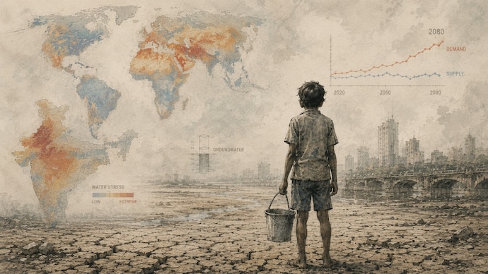
As a weak monsoon dries up taps from Delhi to Chennai, the WRI Aqueduct atlas shows the deeper imbalance: by the 2080s, almost the whole country will want more water than it has.
This summer, Delhi's water supply ran nearly a third below what the city needed. An estimated 28 lakh residents were left without a reliable supply, and the Delhi Jal Board pressed about 960 tankers into service. A 4,000-litre private tanker that normally costs Rs 500 was changing hands for Rs 5,000.
In Chennai, the Veeranam Lake, one of the city's main resources, ran dry. The same summer scramble returned to Bengaluru, Hyderabad, and dozens of smaller towns.
The taps ran drier this year for a reason. By the end of June, India's 2026 monsoon was running about 40 per cent below normal — the fifth-driest June since 1901 — as a strengthening El Nino choked off rains. On June 30, the India Meteorological Department cut its full-season outlook to 90 per cent of normal and forecast a below-normal July, the wettest month of the season.
But a weak monsoon is the trigger, not the cause. Beneath each summer's shortage sits a slower imbalance between what India takes from its water and what nature puts back. The Central Ground Water Board's 2025 assessment rates 730 of the country's 6,762 groundwater blocks as over-exploited, with Punjab, Haryana, and Rajasthan pumping out more than the rains put back.
The World Resources Institute's Aqueduct 4.0 water-risk atlas shows where that imbalance is headed. By the 2080s, the atlas projects that 96 per cent of India's land area will sit in the top two tiers of water demand. Today, just over half the country already lives with extremely high water stress. The pressure is no longer a single dry corner. Almost the whole country is set to want more water.
ALREADY STRESSED
This is not a problem that will wait for 2080. On Aqueduct's present-day baseline, 52 per cent of India's land area sits under extremely high water stress, meaning it draws down more than 80 per cent of the water available to it every year. Add the tier just below, and 69 per cent of the country is under high or extremely high stress today. On the atlas's broader water-risk score, 81 per cent of India's land falls in the worst band.
Stress is the worst where crops are. Haryana, Rajasthan, Delhi, and Punjab rank among the most water-stressed sub-national units in the entire atlas, not only in India. The deep red runs straight across the Ganga plain, the country's farm heartland. About 87 per cent of India's groundwater draw goes to farming, according to the Jal Shakti Ministry. The blocks that the 2025 assessment marks as over-exploited are clustered in that same northern belt. That is the starting point. The 2080 projection widens it.
WHERE DEMAND IS HEADED
The demand surge is near universal: 90 per cent of India's land falls in the very highest band of projected demand. What changes from place to place is the water there to meet it.
For about three-quarters of the country, that high demand still pairs with an adequate supply: the purple and blue basins on the map. These are places of heavy use, but with water on hand. The danger corner is sharper: roughly five per cent of India's area combines high demand with the lowest tier of supply. Those are the orange basins that cluster in the arid north-west.
The north-west, glowing orange on the map, is also India's breadbasket. Punjab, Haryana, and western Uttar Pradesh grow much of the country's wheat and rice on groundwater that is already being drawn faster than the monsoon puts back. The 2080 map deepens that pattern rather than breaking it.
CAN THE MAP BE REDRAWN?
A basin's colour is not fixed. Aqueduct's future layer is a projection under a business-as-usual scenario, not a forecast of what has to happen. It assumes today's trends in population, economy and climate carry on unchecked. Change the demand side, through drip irrigation, less thirsty crops or recharged aquifers, and much of the map can be redrawn. The supply side is far harder to move.
And in the Ganga basin, even the supply-side fixes are limited. A recent study in Nature Water finds that managed aquifer recharge, deliberately banking surplus monsoon flows underground, could offset only three to seven per cent of the basin's unsustainable irrigation, against more than 50 per cent in parts of Europe and Southeast Asia. The place that most needs to refill its aquifers is among the hardest to.
That is where the stakes sit. In the north-west, high demand meets low supply, and the room to manoeuvre is the smallest. If demand keeps climbing while supply thins, the choice narrows to using less water or growing less food in the region that feeds much of the country.
For most of India, the atlas does not show a country running dry. It shows a country reaching for water all at once. And in the north-west, some hands close on nothing.