Satellite images show new water pool behind 2025 Dharali mudflow debris in Uttarakhand
As the Bhagirathi swells again, satellite images show a new warning sign in the Dharali-Harsil valley.
Nearly a year after a mudflow swept through Dharali in Uttarkashi, fear has returned to the upper Bhagirathi valley. In Harsil, residents say the Bhagirathi is rising again, eating into its banks and threatening homes, government buildings and nearby infrastructure. But their larger concern is a temporary water pool forming upstream of the Harsil-Dharali stretch, close to the area reshaped by last year’s disaster.
On August 5, 2025, debris and mudflows from the Tel Gad and Kheer Gad streams tore through the Harshil-Dharali belt of Uttarkashi, sweeping away houses and forcing a lasting shift in the Bhagirathi’s channel.
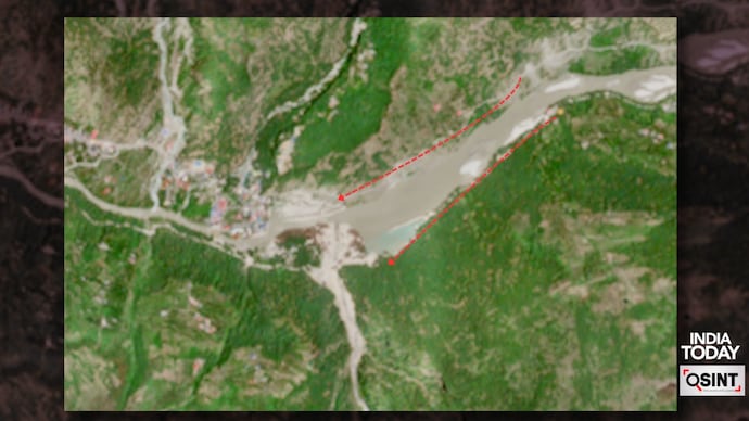
Satellite imagery from the European Union’s Copernicus programme analysed by India Today shows a newly formed localised water pool spread over nearly 2 lakh square metres, roughly the size of 28 football fields, on the Bhagirathi riverbed upstream of Dharali. The pool appears to have formed just behind debris deposits left by last year’s mudflow, where loose sediment, boulders and river material partially choked the valley floor and altered the river’s natural course.
The obstruction appears to have changed the Bhagirathi’s natural thalweg, its lowest flow path, forcing the river through a narrower, more constricted downstream channel and creating conditions for localised ponding and backwater accumulation.
Over the past two weeks, the water spread has visibly increased, likely driven by a combination of monsoon runoff, snowmelt and glacier-fed discharge entering the upper Bhagirathi system. In high-altitude Himalayan channels, even temporary ponding behind unconsolidated debris can be unstable. If the obstruction weakens or fails, water and sediment could be released abruptly downstream, increasing the risk of bank collapse, channel avulsion, flash flooding or renewed debris flow toward the Harsil-Dharali stretch.
The time-series Sentinel-2 imagery shows a clear shift in the Bhagirathi’s channel behaviour near Harsil-Dharali. In the October 2024 and June 2025 frames, the river appears to follow a relatively open, braided course through the valley floor. The active channel is visible as a pale, sediment-laden flow, with no major standing water body in the riverbed.
By October 2025, after the disaster, the river morphology appears visibly altered. A large mass of debris and sediment seems to occupy part of the original channel, forcing the Bhagirathi to bend around it and flow through a narrower passage along the valley margin. The downstream channel appears constricted, suggesting that the river’s natural thalweg had shifted after the debris deposition.
The February 2026 image shows that this altered flow pattern persisted through the winter. The river remains diverted, with water collecting upstream of the debris-choked section. This indicates that the obstruction was not temporary and may have continued to influence the river’s hydraulics months after the initial event.
The June 2026 frames show a sharper change. By June 6, the river corridor appears swollen, with increased wet sediment and water spread across the debris-filled reach. By June 29, a distinct ponded water body is visible upstream of the debris deposit. The pool appears to have expanded within the blocked channel, while the downstream outlet remains narrow and controlled by the debris mass.
The imagery suggests partial impoundment of the Bhagirathi behind unconsolidated debris, likely left by the earlier debris-flow event. Instead of draining freely, the river appears to be backing up behind sediment and boulder deposits, creating a temporary water pool.
This is significant because debris-blocked mountain channels can be unstable. Continued monsoon runoff, snowmelt and glacier-fed discharge can increase water volume, raise hydraulic pressure on the debris plug, saturate the riverbanks and weaken the obstruction.
Ashim Sattar, a GLOF researcher from IIT Bhubaneswar, spoke to India Today: “Initially, the narrowing of downstream channel led to swelling of the river, and later the water drained off. However, now during peak rainfall runoff and seasonal glacier melt, the upstream discharge has collected there again.”
He added that the situation is now “completely out of danger,” but also said it was not possible to determine whether it posed a downstream risk without a detailed analysis. According to him, the present swelling is linked to monsoonal rainfall and seasonal meltwater accumulating at a narrowed section of the Bhagirathi channel.
The glacier images from Sentinel 2 analysed by India Today also show a visible retreat of snow and ice cover in the high-altitude catchment above Dharali between May 2025 and May 2026. Areas that appeared more continuously snow-covered look increasingly fragmented in later images, with larger patches of exposed rock, moraine and valley slopes becoming visible.
The change is most pronounced in the 2026 imagery, where the snowline appears to have moved upslope and meltwater channels are more clearly exposed. The pattern points to accelerated seasonal melting in the glacier-fed basin that drains into the upper Bhagirathi system.
Nearly a year after a mudflow swept through Dharali in Uttarkashi, fear has returned to the upper Bhagirathi valley. In Harsil, residents say the Bhagirathi is rising again, eating into its banks and threatening homes, government buildings and nearby infrastructure. But their larger concern is a temporary water pool forming upstream of the Harsil-Dharali stretch, close to the area reshaped by last year’s disaster.
On August 5, 2025, debris and mudflows from the Tel Gad and Kheer Gad streams tore through the Harshil-Dharali belt of Uttarkashi, sweeping away houses and forcing a lasting shift in the Bhagirathi’s channel.
Satellite imagery from the European Union’s Copernicus programme analysed by India Today shows a newly formed localised water pool spread over nearly 2 lakh square metres, roughly the size of 28 football fields, on the Bhagirathi riverbed upstream of Dharali. The pool appears to have formed just behind debris deposits left by last year’s mudflow, where loose sediment, boulders and river material partially choked the valley floor and altered the river’s natural course.
The obstruction appears to have changed the Bhagirathi’s natural thalweg, its lowest flow path, forcing the river through a narrower, more constricted downstream channel and creating conditions for localised ponding and backwater accumulation.
Over the past two weeks, the water spread has visibly increased, likely driven by a combination of monsoon runoff, snowmelt and glacier-fed discharge entering the upper Bhagirathi system. In high-altitude Himalayan channels, even temporary ponding behind unconsolidated debris can be unstable. If the obstruction weakens or fails, water and sediment could be released abruptly downstream, increasing the risk of bank collapse, channel avulsion, flash flooding or renewed debris flow toward the Harsil-Dharali stretch.
The time-series Sentinel-2 imagery shows a clear shift in the Bhagirathi’s channel behaviour near Harsil-Dharali. In the October 2024 and June 2025 frames, the river appears to follow a relatively open, braided course through the valley floor. The active channel is visible as a pale, sediment-laden flow, with no major standing water body in the riverbed.
By October 2025, after the disaster, the river morphology appears visibly altered. A large mass of debris and sediment seems to occupy part of the original channel, forcing the Bhagirathi to bend around it and flow through a narrower passage along the valley margin. The downstream channel appears constricted, suggesting that the river’s natural thalweg had shifted after the debris deposition.
The February 2026 image shows that this altered flow pattern persisted through the winter. The river remains diverted, with water collecting upstream of the debris-choked section. This indicates that the obstruction was not temporary and may have continued to influence the river’s hydraulics months after the initial event.
The June 2026 frames show a sharper change. By June 6, the river corridor appears swollen, with increased wet sediment and water spread across the debris-filled reach. By June 29, a distinct ponded water body is visible upstream of the debris deposit. The pool appears to have expanded within the blocked channel, while the downstream outlet remains narrow and controlled by the debris mass.
The imagery suggests partial impoundment of the Bhagirathi behind unconsolidated debris, likely left by the earlier debris-flow event. Instead of draining freely, the river appears to be backing up behind sediment and boulder deposits, creating a temporary water pool.
This is significant because debris-blocked mountain channels can be unstable. Continued monsoon runoff, snowmelt and glacier-fed discharge can increase water volume, raise hydraulic pressure on the debris plug, saturate the riverbanks and weaken the obstruction.
Ashim Sattar, a GLOF researcher from IIT Bhubaneswar, spoke to India Today: “Initially, the narrowing of downstream channel led to swelling of the river, and later the water drained off. However, now during peak rainfall runoff and seasonal glacier melt, the upstream discharge has collected there again.”
He added that the situation is now “completely out of danger,” but also said it was not possible to determine whether it posed a downstream risk without a detailed analysis. According to him, the present swelling is linked to monsoonal rainfall and seasonal meltwater accumulating at a narrowed section of the Bhagirathi channel.
The glacier images from Sentinel 2 analysed by India Today also show a visible retreat of snow and ice cover in the high-altitude catchment above Dharali between May 2025 and May 2026. Areas that appeared more continuously snow-covered look increasingly fragmented in later images, with larger patches of exposed rock, moraine and valley slopes becoming visible.
The change is most pronounced in the 2026 imagery, where the snowline appears to have moved upslope and meltwater channels are more clearly exposed. The pattern points to accelerated seasonal melting in the glacier-fed basin that drains into the upper Bhagirathi system.