Phones buzz with 'extremely severe alert' as rain, storm likely in parts of UP
Ghaziabad, Aligarh, Mathura and Meerut are among the districts likely to be impacted by the storm. The message, broadcast at around 8.50 pm in both Hindi and English, flashed on smartphones with a loud notification tone.
Mobile phones buzzed across Delhi-NCR and several surrounding parts of northern India on Thursday as people received an emergency alert warning of a severe thunderstorm, accompanied by lightning, downpour and winds up to 100 kmph, in several parts of western Uttar Pradesh.
Ghaziabad, Aligarh, Mathura and Meerut are among the districts likely to be impacted by the storm. The message, broadcast at around 8.50 pm on Thursday in both Hindi and English, flashed on smartphones with a startling notification tone, cautioning users about the possibility of a moderate to intense spell of rain and hail along with thunderstorms over the coming three hours.
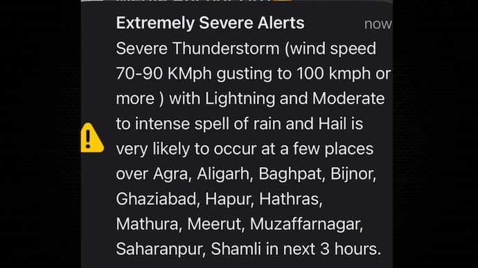
Titled "Extremely Severe Alerts", the emergency alert read, "Severe Thunderstorm (wind speed 70-90 KMph gusting to 100 kmph or more) with Lightning and Moderate to intense spell of rain and Hail is very likely to occur at a few places over Agra, Aligarh, Baghpat, Bijnor, Ghaziabad, Hapur, Hathras, Mathura, Meerut, Muzaffarnagar, Saharanpur, Shamli in next 3 hours (sic)."
A second such alert, a more localised one, was received on smartphones in Delhi-NCR a little more than 2 hours after the initial notification.
"Severe Thunderstorm (wind speed 70-90 KMph gusting to 100 kmph or more) with Lightning and Moderate to intense spell of rain and Hail is very likely to occur at a few places over your district in next 3 hours (sic)," it stated.
IMD'S ORANGE ALERT FOR DELHI
Prior to the emergency alerts, Delhi witnessed a slight dip in temperatures during the day and the weather department issued an orange alert for strong winds, thunderstorms and dust storms during the evening and night hours.
According to the India Meteorological Department (IMD), Safdarjung, Delhi's base station, recorded a maximum temperature of 38.7 degrees Celsius, 1.2 degrees below normal. The "feels like" temperature, however, climbed to 44.4 degrees Celsius.
Among other weather observation stations, Ridge logged a maximum of 38.1 degrees Celsius, 2.2 degrees below normal, while Ayanagar reported 38.0 degrees Celsius, 3.5 degrees below normal. Meanwhile, Palam and Lodhi Road recorded maximum temperatures of 37.8 degrees Celsius each, 2.4 degrees and 1.2 degrees below normal, respectively.
The minimum temperature at Safdarjung was recorded at 30 degrees Celsius, which was 2 degrees Celsius higher than normal. Ayanagar recorded the highest minimum temperature at 30.6 degrees Celsius, 3.1 degrees above normal.
The minimum temperature at Lodhi Road settled at 28.8 degrees Celsius, 0.8 degrees above normal. At the same time, Ridge and Palam logged minimum temperatures of 28.4 degrees Celsius and 28.6 degrees Celsius, which were 1.8 degrees and 0.5 degrees above normal, respectively.
Mobile phones buzzed across Delhi-NCR and several surrounding parts of northern India on Thursday as people received an emergency alert warning of a severe thunderstorm, accompanied by lightning, downpour and winds up to 100 kmph, in several parts of western Uttar Pradesh.
Ghaziabad, Aligarh, Mathura and Meerut are among the districts likely to be impacted by the storm. The message, broadcast at around 8.50 pm on Thursday in both Hindi and English, flashed on smartphones with a startling notification tone, cautioning users about the possibility of a moderate to intense spell of rain and hail along with thunderstorms over the coming three hours.
Titled "Extremely Severe Alerts", the emergency alert read, "Severe Thunderstorm (wind speed 70-90 KMph gusting to 100 kmph or more) with Lightning and Moderate to intense spell of rain and Hail is very likely to occur at a few places over Agra, Aligarh, Baghpat, Bijnor, Ghaziabad, Hapur, Hathras, Mathura, Meerut, Muzaffarnagar, Saharanpur, Shamli in next 3 hours (sic)."
A second such alert, a more localised one, was received on smartphones in Delhi-NCR a little more than 2 hours after the initial notification.
"Severe Thunderstorm (wind speed 70-90 KMph gusting to 100 kmph or more) with Lightning and Moderate to intense spell of rain and Hail is very likely to occur at a few places over your district in next 3 hours (sic)," it stated.
IMD'S ORANGE ALERT FOR DELHI
Prior to the emergency alerts, Delhi witnessed a slight dip in temperatures during the day and the weather department issued an orange alert for strong winds, thunderstorms and dust storms during the evening and night hours.
According to the India Meteorological Department (IMD), Safdarjung, Delhi's base station, recorded a maximum temperature of 38.7 degrees Celsius, 1.2 degrees below normal. The "feels like" temperature, however, climbed to 44.4 degrees Celsius.
Among other weather observation stations, Ridge logged a maximum of 38.1 degrees Celsius, 2.2 degrees below normal, while Ayanagar reported 38.0 degrees Celsius, 3.5 degrees below normal. Meanwhile, Palam and Lodhi Road recorded maximum temperatures of 37.8 degrees Celsius each, 2.4 degrees and 1.2 degrees below normal, respectively.
The minimum temperature at Safdarjung was recorded at 30 degrees Celsius, which was 2 degrees Celsius higher than normal. Ayanagar recorded the highest minimum temperature at 30.6 degrees Celsius, 3.1 degrees above normal.
The minimum temperature at Lodhi Road settled at 28.8 degrees Celsius, 0.8 degrees above normal. At the same time, Ridge and Palam logged minimum temperatures of 28.4 degrees Celsius and 28.6 degrees Celsius, which were 1.8 degrees and 0.5 degrees above normal, respectively.