One Sunday, two extremes: Heavy rain to hit Assam, heat to grip Uttar Pradesh
Assam and Meghalaya are set for extremely heavy rain on Sunday while Uttar Pradesh remains under heat wave conditions. The split weather pattern is being driven by the monsoon trough, cyclonic circulations and a delayed monsoon over the northern plains.
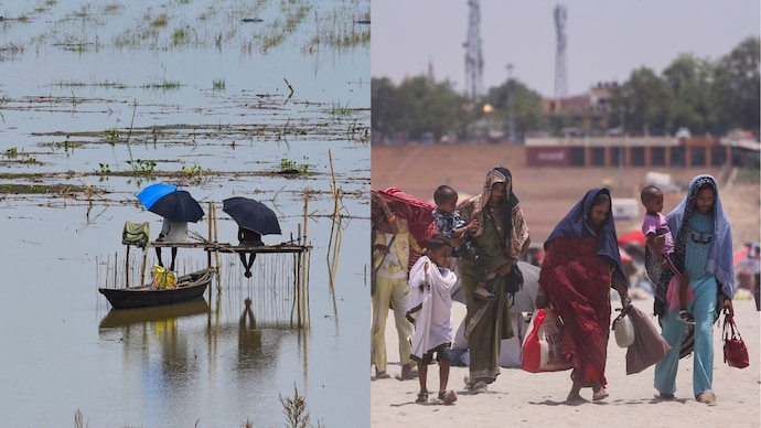
Look at India's skies on Sunday, June 28, and you will see two countries at once. In the far east, Assam and Meghalaya are bracing for rain so heavy the weather office has reached for its rarest label.
A thousand kilometres away, Uttar Pradesh is gasping under a heat wave. Same nation, same day, opposite skies. The reason is not chaos. It is physics.
WHY ARE ASSAM AND MEGHALAYA SET FOR EXTREMELY HEAVY RAIN?
The India Meteorological Department (IMD) expects extremely heavy rainfall over Assam and Meghalaya on June 28. Extremely heavy is the top of the IMD's scale, more than 204.4 millimetres of rain in a single day.
The cause is the land itself. Moist winds sweeping in from the Bay of Bengal strike the Meghalaya hills and are forced sharply upward.
As the air climbs, it cools, and the moisture it carries condenses into cloud and rain. Scientists call this orographic lifting, the simple act of a mountain wringing water out of the sky.
Sub-Himalayan West Bengal and Sikkim face the same punishment from June 27 to 29.
WHY IS UTTAR PRADESH STILL UNDER A HEAT WAVE?
While the east drowns, the plains of Uttar Pradesh bake. The IMD has warned of heat wave to severe heat wave conditions there.
A heat wave is declared when the day's maximum touches at least 40 degrees Celsius and sits well above normal for the date.
The monsoon, the seasonal wind system that delivers most of India's rain, has not yet reached these northern plains. Until those rain-bearing winds arrive, dry, sun-heated air lingers over the region with nothing to cool it.
Relief is on its way, just not on Sunday.
WHAT IS THE MONSOON TROUGH STEERING ALL THIS WEATHER?
Stretching across the country is a monsoon trough, a long belt of low air pressure running, on June 28, from Punjab to Bihar.
Picture a gutter in the atmosphere into which moist sea winds drain, and along which rain gathers.
Sitting on this belt are several cyclonic circulations, swirls of rotating air that pull in moisture and spark storms, over Telangana, Gujarat, Chhattisgarh and the Bay of Bengal.
A Western Disturbance, a rain-bearing system that travels in from the Mediterranean, hovers over Haryana. Together these systems decide who gets soaked and who stays parched.
WILL IT RAIN IN DELHI ON SUNDAY?
Delhi sits on the frontier between the wet east and the hot north-west.
The IMD expects a partly cloudy sky, a thundery burst by afternoon, gusty winds reaching 40 kilometres per hour, and the mercury between 39 and 41 degrees Celsius.
Behind the whole season stands El Nino, a periodic warming of the Pacific Ocean that tends to weaken the Indian monsoon, which is why 2026's rains are forecast to fall below normal.
On Sunday, India is simply living out that tug of war, one half waiting for the rain, the other watching it pour.