Delhi weather update: IMD issues orange alert, showers, thunderstorms likely today
Delhi is under a yellow alert as rain and thunderstorms continue, with showers likely till July 8. The IMD has also warned of heavy to extremely heavy rainfall over Gujarat, Konkan, Odisha and central India.
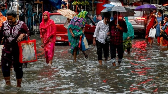
Keep the umbrella within reach. Showers and thunderstorms accompanied by lightning are likely in Delhi on Saturday, July 4, and the India Meteorological Department (IMD) has upgraded parts of the capital from a yellow to an orange alert as the rain intensifies.
In its latest district-level nowcast issued at 1.13 pm, valid till 4.13 pm, the weather office warned of thunderstorms and lightning with moderate rain, along with gusty winds of 30 to 40 kmph, over parts of South East Delhi, East Delhi, Shahdara, Central Delhi, North East Delhi, South Delhi, New Delhi, South West Delhi, West Delhi, North West Delhi and North Delhi.
Earlier in the day, in its district-level nowcast issued at 10.20 am, valid till 12.20 pm, the weather office had warned of light to moderate rain, light thunderstorm with lightning, and gusty winds of 30 to 40 kmph over parts of Shahdara, Central Delhi, North East Delhi, New Delhi, West Delhi, North West Delhi and North Delhi.
The southern districts, which carried no warning in the morning, are now under alert too, with only a few pockets on the city's southern edge still in the green.
A yellow alert is the second rung on the IMD's four-colour warning ladder. Green means all is well. Yellow means be aware. Orange means be prepared. Red means take action. The upgrade to orange means Delhi is being asked to move from awareness to preparedness, though this is still not a disaster warning.
It is being told to keep an umbrella handy, expect traffic snarls and waterlogging in low-lying areas, and stay away from trees and water bodies when lightning strikes.
DELHI WEATHER'S ON JULY 4: WHAT IS THE FORECAST?
The Southwest Monsoon advanced over Delhi around Thursday, July 2, and rain and thunderstorms are likely to continue over the weekend.
The showers have already pulled the maximum temperature down to around 33 degrees Celsius, more than four degrees below normal, and daytime temperatures are expected to stay between 33 and 38 degrees Celsius until July 8.
Delhi's monsoon rain arrives in sharp, localised bursts rather than a steady all-day drizzle.
Moist winds from the Arabian Sea and the Bay of Bengal are streaming over north India, and when this humid air is heated from below and forced to rise, it cools, its water vapour condenses, and thunderclouds erupt.
One neighbourhood can get drenched while another stays dry. The morning-to-afternoon flip in Delhi's own nowcast map, from a half-yellow city to a nearly all-orange one in three hours, is a live demonstration of how fast monsoon convection builds.
WHICH STATES ARE ON ALERT FOR HEAVY RAINFALL?
The bigger engine lies far from Delhi. A low pressure area, a region where air pressure is lower than its surroundings, has formed over the northwest Bay of Bengal. Air rushes into it, rises, and wrings out enormous amounts of moisture as rain.
Under its influence, the IMD expects heavy to very heavy rainfall, with isolated extremely heavy spells, over Gujarat, Konkan and Goa, Madhya Maharashtra, Odisha, and West Madhya Pradesh.
Coastal Karnataka, East Madhya Pradesh, Chhattisgarh, East Rajasthan, Telangana and Vidarbha are also on watch. In IMD's rulebook, heavy rain means 64.5 to 115.5 mm in 24 hours, very heavy means up to 204.4 mm, and extremely heavy means anything beyond that.
Such systems are the workhorses of the monsoon. A study in the Journal of Climate, analysing over a century of rainfall data, found that these low pressure systems drive the most dominant rainfall pattern of the active monsoon.
Along the west coast, moist sea winds slamming into the Western Ghats add an extra push, a process called orographic lifting.
IS IT SAFE AT SEA?
No. Squally winds of 45 to 55 kmph, gusting to 65 kmph, are sweeping the Arabian Sea and the Bay of Bengal, and fishermen have been advised against venturing out.
Off Somalia and Oman, this is the signature of the Somali Jet, a powerful low-level wind stream that ferries moisture towards India every monsoon.
The bottom line for Delhi: the monsoon has settled in, the atmosphere is loaded, and the umbrella stays by the door until at least July 8.