Gujarat monsoon: Vigorous rain hits triple centuries three days in a row
The extreme downpours have triggered widespread flooding, disrupted transport and prompted fresh warnings of more heavy rain, with no relief in sight.
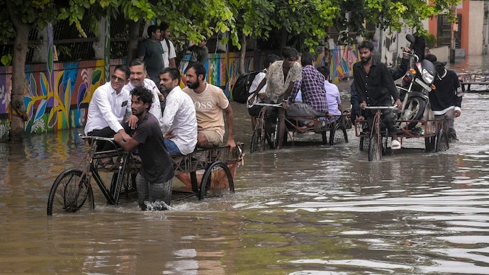
Gujarat's relentless monsoon has entered record territory, with the state witnessing 300 mm-plus rainfall in at least one location for three consecutive days.
The latest spell has brought widespread flooding, disrupted transport and inundated several towns across north and central Gujarat, making it one of the most intense phases of this year's southwest monsoon.
According to the State Emergency Operation Centre (SEOC), rainfall data for the 24-hour period ending 6 am on July 25 showed Santalpur in Patan district receiving 381 mm of rain, the highest in the state.
Radhanpur followed with 342 mm, while Bhabhar in Vav-Tharad recorded 287 mm.
Other areas that received exceptionally heavy rainfall included Deodar (275 mm), Nadiad (262 mm) and Mehmedabad (213 mm).
The latest figures come after Gujarat recorded more than 300 mm of rainfall in at least one location on each of the previous two days as well, underscoring the persistence of the current extreme weather spell.
NORTH GUJARAT FACES THE WORST
The heaviest rain has been concentrated over north and parts of central Gujarat, where overflowing rivers, waterlogged roads and flooded residential areas have affected normal life.
Districts such as Patan, Banaskantha, Kheda, Surendranagar, Morbi and Gandhinagar have repeatedly featured among the state's wettest regions over the past several days.
Earlier this week, Ahmedabad also witnessed one of its wettest days in decades, receiving nearly 295 mm of rain in 24 hours.
The city experienced widespread flooding, traffic disruptions and temporary closure of several roads as the intense downpour overwhelmed drainage systems.
The ongoing spell has been driven by an active southwest monsoon supported by favourable weather systems over western India, allowing successive rain-bearing clouds to move across the same regions.
MORE HEAVY RAIN ON THE WAY
The India Meteorological Department (IMD) has forecast that Gujarat will continue to experience an active monsoon through the coming week.
Heavy to very heavy rainfall is likely over several districts, with isolated extremely heavy rainfall expected over parts of north Gujarat and adjoining regions over the next few days.
Rainfall intensity is expected to remain high through the weekend before gradually easing in some areas later next week, although widespread monsoon showers are likely to continue until at least July 30.
With catchments already saturated after successive days of intense rain, even moderate to heavy showers could continue to worsen flooding in vulnerable areas.
Gujarat's relentless monsoon has entered record territory, with the state witnessing 300 mm-plus rainfall in at least one location for three consecutive days.
The latest spell has brought widespread flooding, disrupted transport and inundated several towns across north and central Gujarat, making it one of the most intense phases of this year's southwest monsoon.
According to the State Emergency Operation Centre (SEOC), rainfall data for the 24-hour period ending 6 am on July 25 showed Santalpur in Patan district receiving 381 mm of rain, the highest in the state.
Radhanpur followed with 342 mm, while Bhabhar in Vav-Tharad recorded 287 mm.
Other areas that received exceptionally heavy rainfall included Deodar (275 mm), Nadiad (262 mm) and Mehmedabad (213 mm).
The latest figures come after Gujarat recorded more than 300 mm of rainfall in at least one location on each of the previous two days as well, underscoring the persistence of the current extreme weather spell.
NORTH GUJARAT FACES THE WORST
The heaviest rain has been concentrated over north and parts of central Gujarat, where overflowing rivers, waterlogged roads and flooded residential areas have affected normal life.
Districts such as Patan, Banaskantha, Kheda, Surendranagar, Morbi and Gandhinagar have repeatedly featured among the state's wettest regions over the past several days.
Earlier this week, Ahmedabad also witnessed one of its wettest days in decades, receiving nearly 295 mm of rain in 24 hours.
The city experienced widespread flooding, traffic disruptions and temporary closure of several roads as the intense downpour overwhelmed drainage systems.
The ongoing spell has been driven by an active southwest monsoon supported by favourable weather systems over western India, allowing successive rain-bearing clouds to move across the same regions.
MORE HEAVY RAIN ON THE WAY
The India Meteorological Department (IMD) has forecast that Gujarat will continue to experience an active monsoon through the coming week.
Heavy to very heavy rainfall is likely over several districts, with isolated extremely heavy rainfall expected over parts of north Gujarat and adjoining regions over the next few days.
Rainfall intensity is expected to remain high through the weekend before gradually easing in some areas later next week, although widespread monsoon showers are likely to continue until at least July 30.
With catchments already saturated after successive days of intense rain, even moderate to heavy showers could continue to worsen flooding in vulnerable areas.
Gujarat's relentless monsoon has entered record territory, with the state witnessing 300 mm-plus rainfall in at least one location for three consecutive days.
The latest spell has brought widespread flooding, disrupted transport and inundated several towns across north and central Gujarat, making it one of the most intense phases of this year's southwest monsoon.
According to the State Emergency Operation Centre (SEOC), rainfall data for the 24-hour period ending 6 am on July 25 showed Santalpur in Patan district receiving 381 mm of rain, the highest in the state.
Radhanpur followed with 342 mm, while Bhabhar in Vav-Tharad recorded 287 mm.
Other areas that received exceptionally heavy rainfall included Deodar (275 mm), Nadiad (262 mm) and Mehmedabad (213 mm).
The latest figures come after Gujarat recorded more than 300 mm of rainfall in at least one location on each of the previous two days as well, underscoring the persistence of the current extreme weather spell.
NORTH GUJARAT FACES THE WORST
The heaviest rain has been concentrated over north and parts of central Gujarat, where overflowing rivers, waterlogged roads and flooded residential areas have affected normal life.
Districts such as Patan, Banaskantha, Kheda, Surendranagar, Morbi and Gandhinagar have repeatedly featured among the state's wettest regions over the past several days.
Earlier this week, Ahmedabad also witnessed one of its wettest days in decades, receiving nearly 295 mm of rain in 24 hours.
The city experienced widespread flooding, traffic disruptions and temporary closure of several roads as the intense downpour overwhelmed drainage systems.
The ongoing spell has been driven by an active southwest monsoon supported by favourable weather systems over western India, allowing successive rain-bearing clouds to move across the same regions.
MORE HEAVY RAIN ON THE WAY
The India Meteorological Department (IMD) has forecast that Gujarat will continue to experience an active monsoon through the coming week.
Heavy to very heavy rainfall is likely over several districts, with isolated extremely heavy rainfall expected over parts of north Gujarat and adjoining regions over the next few days.
Rainfall intensity is expected to remain high through the weekend before gradually easing in some areas later next week, although widespread monsoon showers are likely to continue until at least July 30.
With catchments already saturated after successive days of intense rain, even moderate to heavy showers could continue to worsen flooding in vulnerable areas.

