Monsoon mayhem: How 5 weather systems ganged up over India to bring intense rain
Five weather systems, led by a well-marked low pressure area over the Bay of Bengal, are keeping India's monsoon active, says the IMD. Extremely heavy rain is likely over Konkan, Gujarat, Maharashtra and Odisha over the next few days.
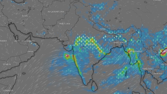
The monsoon has roared back to life. After a sluggish June, rain is now hammering India's west coast, drenching central India and inching towards the last dry corners of Rajasthan.
According to the India Meteorological Department (IMD), five weather systems are working together at once to keep the monsoon in an active phase for the next four to five days.
WHAT IS THE LOW PRESSURE AREA OVER THE BAY OF BENGAL?
The most powerful of the five is a well-marked low pressure area over the Northwest Bay of Bengal.
A low pressure area is a patch of the atmosphere where air rises, cools and condenses into rain clouds.
The IMD says this system will keep the monsoon active over central India as it moves west-northwestwards across north Odisha and north Chhattisgarh over the next three days.
WHICH OTHER WEATHER SYSTEMS ARE ACTIVE OVER INDIA?
Four more systems are amplifying the rain.
The monsoon trough, an elongated belt of low pressure stretching across the country, is active and sitting south of its normal position, which favours heavy rain over central India.
A shear zone lies along latitude 21 degrees north. This is a region where winds at different heights blow at different speeds or directions, churning the atmosphere and helping storm clouds grow taller.
An offshore trough runs from south Gujarat to the Karnataka coast. Think of it as a conveyor belt that continuously pulls moist air from the Arabian Sea onto the west coast, which is why Konkan and coastal Karnataka are being lashed.
And a Western Disturbance, a rain-bearing system that travels in from the west, persists over northern India, adding to the rain over the hills and plains of the northwest.
WHERE HAS THE HEAVIEST RAIN FALLEN IN INDIA?
The numbers are staggering. Mangrol in Gujarat's Junagadh district recorded 57 centimetres of rain in 24 hours, which the IMD classifies as exceptionally heavy.
Mahabaleshwar in Maharashtra logged 27 centimetres, Poladpur in Raigad 22 centimetres and Sendhwa in Madhya Pradesh 21 centimetres. Thunderstorms with winds touching 70 kilometres per hour swept Dabok in East Rajasthan.
WHICH STATES ARE ON ALERT FOR EXTREMELY HEAVY RAIN?
The IMD has warned of isolated extremely heavy rainfall, or more than 20 centimetres in a day, over Konkan and the Gujarat region until July 7, Madhya Maharashtra until July 6, and Saurashtra and Odisha on July 5.
Residents should expect waterlogged roads, traffic disruption and possible landslides in hilly areas. Fishermen have been told to stay out of large parts of the Arabian Sea and the Bay of Bengal until July 8 and 9.
WILL THE MONSOON COVER THE REST OF INDIA SOON?
Yes, conditions look favourable. The IMD says the monsoon is set to advance into more parts of Gujarat, the remaining areas of Haryana and Punjab, and more of Rajasthan over the next four days.
Delhi, meanwhile, can expect cloudy skies, light rain and gusty winds, with maximum temperatures dipping to around 30 to 32 degrees Celsius by July 7.