Watch: London sky explodes with lightning after major thunderstorm outbreak
A powerful overnight thunderstorm swept from Somerset to London, lighting up the sky with intense flashes. The outbreak brought flooding, outages and a rare pre-dawn display over the capital.
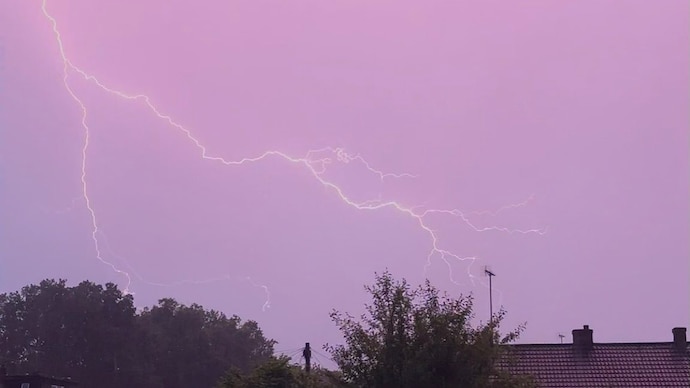
A powerful thunderstorm swept across southern England overnight on June 22, turning the skies into a spectacular light show as hundreds of lightning strikes illuminated the region from Somerset to London.
The severe weather system, which triggered a Yellow Thunderstorm Warning from the UK Met Office, brought torrential rain, frequent lightning, local flooding, and power outages across parts of southwest England. Areas near Glastonbury in Somerset were among the hardest hit as the storm rapidly intensified during the evening and moved eastward.
Lightning detection networks recorded an extraordinary burst of electrical activity, with strike rates exceeding 500 lightning strikes per minute at the peak of the storm.
Nearly 3,000 lightning strikes were detected around London in just two hours, making it one of the most intense lightning outbreaks over the capital in recent years.
Residents witnessed a dramatic transition from darkness to thunderstorms and then daylight in a remarkably short span.
With sunrise approaching at around 3:55 a.m., London experienced an hour unlike any other, moving from pitch-black skies to near-constant flashes of lightning before dawn broke across the city.
Meteorologists said the thunderstorm developed as a plume of warm, humid air surged northward from continental Europe beneath unusually cold air in the upper atmosphere. This sharp contrast created a highly unstable environment favorable for explosive thunderstorm growth.
Satellite imagery showed cloud tops reaching exceptional heights, indicating powerful updrafts capable of transporting moisture and ice particles high into the atmosphere. As these particles collided inside the storm clouds, they generated large electrical charges. When the charge difference between clouds or between clouds and the ground became too great, it was released as lightning.
The resulting electrical activity produced the dazzling display seen across southern England. The storm's structure also allowed lightning to spread over a wide area, creating continuous flashes that illuminated the night sky for hours.
The weather system was further energized by a slow-moving upper-level disturbance over the United Kingdom, which enhanced rising motion in the atmosphere and helped thunderstorms organize into larger storm clusters.
While the lightning show captivated skywatchers, the storm also brought significant disruption. Intense downpours overwhelmed drainage systems in some locations, causing flash flooding on roads and temporary power outages.
Forecasters warned that similar thunderstorms could develop during periods of hot and humid summer weather, particularly when cooler air aloft arrives to destabilize the atmosphere.