Monsoon is stuck: 28% dip in rain as clouds struggle to cover India
India has recorded a 28% rainfall deficit as an unusual upper-air pattern slows the southwest monsoon. Forecasters are watching for a possible revival after 20 June if the easterly jet strengthens.
India's southwest monsoon is showing signs of strain, with the country recording a rainfall deficit of 28% so far this season as an unusual atmospheric pattern slows its advance and suppresses widespread rain.
According to the latest India Meteorological Department (IMD) data, the country received 34.3 mm of rainfall between June 4 and June 14 against a normal of 47.7 mm, leaving a nationwide deficit of 28%.
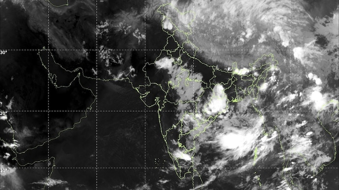
The district-wise rainfall map reveals large swathes of central, eastern and peninsular India experiencing below-normal rainfall, while only a few pockets have recorded excess rain.
The slowdown comes despite the monsoon making further advances into parts of southern and central India in recent days. Meteorologists say the issue is not a lack of moisture but a large-scale atmospheric tug-of-war unfolding high above the region.
At the centre of the problem is the westerly jet stream, a fast-moving river of air in the upper atmosphere that has shifted much farther south than normal. This unusual positioning is suppressing the upper-level easterly jet, a key component that typically helps drive the monsoon circulation across the Indian subcontinent.
As a result, weather systems developing over the Bay of Bengal are struggling to move inland. Without a strong steering mechanism, rain-bearing systems remain weak or are confined to limited areas instead of spreading moisture deep into the country.
The impact is being felt across central India, eastern states and parts of the southern peninsula, where dry spells have become increasingly common during what is normally a period of expanding monsoon activity. In contrast, some isolated districts in northwest India have received brief spells of rainfall due to localised weather disturbances.
The current deficit is raising eyebrows among meteorologists because it appears more severe than many seasonal forecasts issued in May had anticipated. Most long-range models projected a healthy start to the monsoon season, supported by favourable ocean conditions. Instead, the atmosphere has introduced an unexpected obstacle.
There is, however, some optimism for the second half of June. Weather models indicate that the upper-level easterly jet could strengthen after June 20, helping restore the monsoon's momentum. If that happens, rain-bearing systems over the Bay of Bengal may once again begin moving into the mainland, allowing the monsoon to reorganise and spread more effectively across the country.
For now, forecasters are closely watching whether the atmosphere's current stalemate breaks, as the coming weeks could determine whether the monsoon regains lost ground or falls further behind schedule.
India's southwest monsoon is showing signs of strain, with the country recording a rainfall deficit of 28% so far this season as an unusual atmospheric pattern slows its advance and suppresses widespread rain.
According to the latest India Meteorological Department (IMD) data, the country received 34.3 mm of rainfall between June 4 and June 14 against a normal of 47.7 mm, leaving a nationwide deficit of 28%.
The district-wise rainfall map reveals large swathes of central, eastern and peninsular India experiencing below-normal rainfall, while only a few pockets have recorded excess rain.
The slowdown comes despite the monsoon making further advances into parts of southern and central India in recent days. Meteorologists say the issue is not a lack of moisture but a large-scale atmospheric tug-of-war unfolding high above the region.
At the centre of the problem is the westerly jet stream, a fast-moving river of air in the upper atmosphere that has shifted much farther south than normal. This unusual positioning is suppressing the upper-level easterly jet, a key component that typically helps drive the monsoon circulation across the Indian subcontinent.
As a result, weather systems developing over the Bay of Bengal are struggling to move inland. Without a strong steering mechanism, rain-bearing systems remain weak or are confined to limited areas instead of spreading moisture deep into the country.
The impact is being felt across central India, eastern states and parts of the southern peninsula, where dry spells have become increasingly common during what is normally a period of expanding monsoon activity. In contrast, some isolated districts in northwest India have received brief spells of rainfall due to localised weather disturbances.
The current deficit is raising eyebrows among meteorologists because it appears more severe than many seasonal forecasts issued in May had anticipated. Most long-range models projected a healthy start to the monsoon season, supported by favourable ocean conditions. Instead, the atmosphere has introduced an unexpected obstacle.
There is, however, some optimism for the second half of June. Weather models indicate that the upper-level easterly jet could strengthen after June 20, helping restore the monsoon's momentum. If that happens, rain-bearing systems over the Bay of Bengal may once again begin moving into the mainland, allowing the monsoon to reorganise and spread more effectively across the country.
For now, forecasters are closely watching whether the atmosphere's current stalemate breaks, as the coming weeks could determine whether the monsoon regains lost ground or falls further behind schedule.