Rain coming: Satellite spots one western disturbance leaving, another getting ready
Meteorologists are tracking another western disturbance even as the current system moves away from north India. The back-to-back systems could bring more thunderstorms, dust storms and gusty winds later this week.
Even as the current western disturbance continues to influence weather across northern India, meteorologists are already tracking another powerful system that is expected to arrive between June 3 and June 5, raising the possibility of fresh thunderstorms, gusty winds and dust storms across large parts of northwest India.
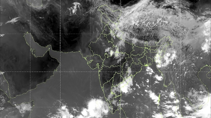
The latest INSAT-3DS thermal infrared satellite imagery from Monday morning paints a dramatic picture of the atmosphere over the Indian subcontinent.
A vast shield of clouds stretches across Jammu and Kashmir, Himachal Pradesh, Uttarakhand and adjoining regions, extending eastward into Nepal and the Himalayan belt. This extensive cloud mass is associated with the western disturbance currently moving away from India.
A Western Disturbance is a weather system that forms over the Mediterranean region and travels eastward toward India. It carries moisture and brings rain, thunderstorms, hail and snowfall to northern India and the Himalayas. During summer, strong western disturbances can also trigger dust storms, lightning and sudden temperature drops across the plains.
The satellite image also reveals a pronounced cyclonic swirl and dense cloud bands over Afghanistan, Pakistan and adjoining areas of Central Asia. These features indicate the presence of another active upper-air disturbance approaching the region.
Meteorologists say this incoming western disturbance is likely to follow closely behind the current system, resulting in back-to-back weather activity over northern India.
The ongoing western disturbance has already triggered thunderstorms, rain and strong winds across several northern states.
However, unlike a typical early-June pattern, in which western disturbances weaken considerably, this year they have remained unusually active and frequent.
Weather experts say the next western disturbance, expected around June 3-5, appears equally potent. As it interacts with hot and moisture-laden air over the plains, conditions could become favourable for severe thunderstorms, lightning and intense dust storms across Punjab, Haryana, Delhi-NCR, Rajasthan and western Uttar Pradesh.
The satellite imagery supports this assessment. While the current disturbance is moving eastward across the Himalayan region, a fresh stream of clouds and atmospheric energy is visible upstream over western Asia, indicating that the weather pattern remains highly dynamic.
The repeated arrival of western disturbances is also helping suppress extreme heat across parts of north India. Frequent cloud cover, rain and dust storms have prevented temperatures from soaring to the levels usually seen during the first week of June.
However, these same systems can create hazardous weather, including sudden wind squalls, reduced visibility during dust storms and localised heavy rainfall.
Forecast models suggest that the next few days could remain unsettled across northwest India, with intermittent spells of rain and thunderstorms continuing even after the current western disturbance exits.
For residents of Delhi-NCR and surrounding states, the message is clear: the weather rollercoaster is far from over. One western disturbance is leaving, but another powerful system is already waiting in the wings, promising another round of stormy conditions later this week.
Even as the current western disturbance continues to influence weather across northern India, meteorologists are already tracking another powerful system that is expected to arrive between June 3 and June 5, raising the possibility of fresh thunderstorms, gusty winds and dust storms across large parts of northwest India.
The latest INSAT-3DS thermal infrared satellite imagery from Monday morning paints a dramatic picture of the atmosphere over the Indian subcontinent.
A vast shield of clouds stretches across Jammu and Kashmir, Himachal Pradesh, Uttarakhand and adjoining regions, extending eastward into Nepal and the Himalayan belt. This extensive cloud mass is associated with the western disturbance currently moving away from India.
A Western Disturbance is a weather system that forms over the Mediterranean region and travels eastward toward India. It carries moisture and brings rain, thunderstorms, hail and snowfall to northern India and the Himalayas. During summer, strong western disturbances can also trigger dust storms, lightning and sudden temperature drops across the plains.
The satellite image also reveals a pronounced cyclonic swirl and dense cloud bands over Afghanistan, Pakistan and adjoining areas of Central Asia. These features indicate the presence of another active upper-air disturbance approaching the region.
Meteorologists say this incoming western disturbance is likely to follow closely behind the current system, resulting in back-to-back weather activity over northern India.
The ongoing western disturbance has already triggered thunderstorms, rain and strong winds across several northern states.
However, unlike a typical early-June pattern, in which western disturbances weaken considerably, this year they have remained unusually active and frequent.
Weather experts say the next western disturbance, expected around June 3-5, appears equally potent. As it interacts with hot and moisture-laden air over the plains, conditions could become favourable for severe thunderstorms, lightning and intense dust storms across Punjab, Haryana, Delhi-NCR, Rajasthan and western Uttar Pradesh.
The satellite imagery supports this assessment. While the current disturbance is moving eastward across the Himalayan region, a fresh stream of clouds and atmospheric energy is visible upstream over western Asia, indicating that the weather pattern remains highly dynamic.
The repeated arrival of western disturbances is also helping suppress extreme heat across parts of north India. Frequent cloud cover, rain and dust storms have prevented temperatures from soaring to the levels usually seen during the first week of June.
However, these same systems can create hazardous weather, including sudden wind squalls, reduced visibility during dust storms and localised heavy rainfall.
Forecast models suggest that the next few days could remain unsettled across northwest India, with intermittent spells of rain and thunderstorms continuing even after the current western disturbance exits.
For residents of Delhi-NCR and surrounding states, the message is clear: the weather rollercoaster is far from over. One western disturbance is leaving, but another powerful system is already waiting in the wings, promising another round of stormy conditions later this week.