Monsoon stalls, western disturbance arrives: Will it bring rain to India Thursday?
A fresh Western Disturbance is set to bring rain, snow and dust storms to northwest India even as the southwest monsoon stalls before its next advance into central India. Here is what the IMD's latest forecast means for Delhi, Rajasthan and the heatwave-hit centre of the country.
A fresh Western Disturbance is set to sweep into northwest India from Thursday, June 18, even as the southwest monsoon remains stalled well short of central India, leaving the country under two very different weather patterns at once.
According to the India Meteorological Department (IMD)’s latest bulletin, the western disturbance, a low-pressure system that originates over the Mediterranean and Caspian seas rather than from the ocean monsoon, will bring widespread rain and snow to the western Himalayas, including Jammu and Kashmir, Ladakh and Himachal Pradesh, with isolated hailstorms expected in the hills.
On the plains below, the same system is forecast to trigger sharper, more sudden weather.
A thundersquall, a brief but intense burst of wind, is likely over West Rajasthan on Thursday, with speeds reaching 60 to 70 kilometres an hour and gusts higher still.
East Rajasthan can expect similar conditions through Friday, June 19. Dust storm activity is also forecast across West Rajasthan through June 19.
MONSOON STALLS SHORT OF CENTRAL INDIA
While the north braces for the Western Disturbance, the southwest monsoon itself remains some distance from completing its annual sweep across the country.
The IMD tracks the monsoon's progress using the Northern Limit of Monsoon, a line marking how far north the system has advanced.
That line currently runs through Harnai, Solapur, Hyderabad, Bhadrachalam, Koraput, Phulbani, Ranchi, Jamui and Muzaffarpur, and has held roughly that position for several days.
The department says conditions are favourable for the monsoon to push further into parts of Telangana, Odisha, Jharkhand, Bihar and Chhattisgarh, but only over the next four to five days, putting the next advance at around June 23.
That delay is the main reason large parts of central India remain hot rather than wet.
Heat wave conditions have been forecast in isolated pockets over Madhya Pradesh until Sunday, June 21, Vidarbha until Saturday, June 20, and Telangana until Friday, June 19.
Prayagraj in Uttar Pradesh recorded the country’s highest temperature this week, at 44 degrees Celsius on June 16.
HEAVY RAIN IN THE EAST AND NORTHEAST
Away from the stalled centre, the monsoon is performing closer to form in the east, drawing heavily on moisture from the Bay of Bengal.
The IMD has forecast heavy to isolated very heavy rainfall over Sub-Himalayan West Bengal, Sikkim, Assam, Arunachal Pradesh and Bihar through the week, along with thunderstorms, lightning and gusty winds reaching 50 to 60 kilometres an hour in parts of Jharkhand and Bihar.
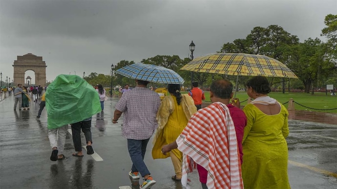
WHAT TO EXPECT IN DELHI
Delhi and the National Capital Region sit at the edge of the Western Disturbance's reach. The IMD forecasts a partly cloudy sky on Thursday, with a chance of very light to light rain and thunderstorms developing towards evening or night.
Maximum temperatures are expected between 37 and 39 degrees Celsius, with minimums between 25 and 27 degrees Celsius, both close to normal for the date.
Winds are forecast from the west, picking up to around 24 kilometres an hour during the day.
FISHERMEN ADVISED OFF THE COAST
The IMD has also warned fishermen against venturing into parts of the Arabian Sea and the Bay of Bengal until June 22, including the Gulf of Mannar, waters off Odisha and Gangetic West Bengal, and stretches near the Somalia and Oman coasts, where squally winds are expected to make conditions rough.
A fresh Western Disturbance is set to sweep into northwest India from Thursday, June 18, even as the southwest monsoon remains stalled well short of central India, leaving the country under two very different weather patterns at once.
According to the India Meteorological Department (IMD)’s latest bulletin, the western disturbance, a low-pressure system that originates over the Mediterranean and Caspian seas rather than from the ocean monsoon, will bring widespread rain and snow to the western Himalayas, including Jammu and Kashmir, Ladakh and Himachal Pradesh, with isolated hailstorms expected in the hills.
On the plains below, the same system is forecast to trigger sharper, more sudden weather.
A thundersquall, a brief but intense burst of wind, is likely over West Rajasthan on Thursday, with speeds reaching 60 to 70 kilometres an hour and gusts higher still.
East Rajasthan can expect similar conditions through Friday, June 19. Dust storm activity is also forecast across West Rajasthan through June 19.
MONSOON STALLS SHORT OF CENTRAL INDIA
While the north braces for the Western Disturbance, the southwest monsoon itself remains some distance from completing its annual sweep across the country.
The IMD tracks the monsoon's progress using the Northern Limit of Monsoon, a line marking how far north the system has advanced.
That line currently runs through Harnai, Solapur, Hyderabad, Bhadrachalam, Koraput, Phulbani, Ranchi, Jamui and Muzaffarpur, and has held roughly that position for several days.
The department says conditions are favourable for the monsoon to push further into parts of Telangana, Odisha, Jharkhand, Bihar and Chhattisgarh, but only over the next four to five days, putting the next advance at around June 23.
That delay is the main reason large parts of central India remain hot rather than wet.
Heat wave conditions have been forecast in isolated pockets over Madhya Pradesh until Sunday, June 21, Vidarbha until Saturday, June 20, and Telangana until Friday, June 19.
Prayagraj in Uttar Pradesh recorded the country’s highest temperature this week, at 44 degrees Celsius on June 16.
HEAVY RAIN IN THE EAST AND NORTHEAST
Away from the stalled centre, the monsoon is performing closer to form in the east, drawing heavily on moisture from the Bay of Bengal.
The IMD has forecast heavy to isolated very heavy rainfall over Sub-Himalayan West Bengal, Sikkim, Assam, Arunachal Pradesh and Bihar through the week, along with thunderstorms, lightning and gusty winds reaching 50 to 60 kilometres an hour in parts of Jharkhand and Bihar.
WHAT TO EXPECT IN DELHI
Delhi and the National Capital Region sit at the edge of the Western Disturbance's reach. The IMD forecasts a partly cloudy sky on Thursday, with a chance of very light to light rain and thunderstorms developing towards evening or night.
Maximum temperatures are expected between 37 and 39 degrees Celsius, with minimums between 25 and 27 degrees Celsius, both close to normal for the date.
Winds are forecast from the west, picking up to around 24 kilometres an hour during the day.
FISHERMEN ADVISED OFF THE COAST
The IMD has also warned fishermen against venturing into parts of the Arabian Sea and the Bay of Bengal until June 22, including the Gulf of Mannar, waters off Odisha and Gangetic West Bengal, and stretches near the Somalia and Oman coasts, where squally winds are expected to make conditions rough.