
From the Editor-in-Chief

The Himalayas are now breeding new peril owing to climate change, with high-altitude disasters that are not periodic aberrations anymore

ISSUE DATE: Sep 14, 2026 | UPDATED: Sep 4, 2026 20:10 IST
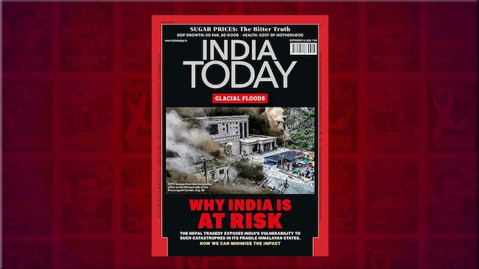
On August 26, a giant slab of glacial ice and bedrock, as wide as 10 cricket stadiums laid end to end, detached from the Langtang Lirung mountain crest on the Nepal-Tibet border and crashed into the steep gorges below for over a kilometre. It generated a monster slurry of pulverised rock, ice and mud moving at 180 kilometres per hour. Residents in the Lhende Khola and Bhote Koshi river valleys got barely minutes to react as a giant fortress wall of black liquid smashed in on them. We all saw it unfold in endless reels: entire villages, border checkposts, bridges, roads and vehicles being washed away. Over 1,200 are dead; nearly 5,000 missing. The scale of such events seems beyond ordinary comprehension. The initial shock here was equivalent to a 5.2 Richter earthquake. The 2021 glacier collapse in Uttarakhand’s Chamoli released energy equal to 15 Hiroshimas. These are not freak events. India is fringed along its entire northern rim by the world’s tallest and most geologically unstable mountain range. We cannot afford to keep treating these events as acts of God beyond human reckoning. We must get a measure of things.
A basic vulnerability-mapping leaves no doubt: India is living with monumental risk. The Himalayas are now breeding new peril owing to climate change. The risk is spread not just along our 2,500-km mountainous rim, spanning 11 states and Union territories, from Ladakh and J&K to Arunachal Pradesh. The rivers that descend from these mountains water the northern plains and have always been prone to flooding. Together, these two geographies place roughly 700 million Indians, or half our population, in proximity to high-altitude disasters that are not periodic aberrations but conditions in permanent formation. Woven into this landscape are hundreds of hydropower projects, with an installed capacity of over 45,000 MW. So, some of India’s most expensive infrastructure is placed smack bang in the path of potential disaster.
Understanding why these events are accelerating requires looking past the visual serenity the Himalayan peaks project. These are young mountains, still rising by up to 10 mm a year, so the bedrock is prone to micro-seismic imbalances. Global warming comes on top of this, increasingly melting what used to be stable permafrost on the crown. That seeps into the pores of the bedrock, weakening its core. As ice retreats, it also removes the support from adjoining slopes. That’s why it was not just a glacial collapse in Nepal, or in Chamoli. The bedrock underneath itself collapsed.
The other disaster we stare at is the Glacial Lake Outburst Flood (GLOF), where a body of water in the high ranges, often building up quietly from melting ice and dammed by rock, suddenly gives way due to excess weight. In Sikkim, a permafrost landslide into the South Lhonak Lake in October 2023 created a tsunami-like wave that swept down the Teesta river. In the Kedarnath tragedy of 2013, a monster cloudburst triggered a GLOF event. Some 16,627 glaciers and 7,570 large glacial lakes lie within our borders. The entire Hindu Kush-Himalayan continuum holds over 63,000 glaciers while the Himalayan region has 28,000+ glacial lakes, not an irrelevant fact since nature’s imbalances do not respect national maps. Studying long-term satellite data, ISRO has found that 676 Himalayan lakes have expanded significantly since 1984; over 600 had doubled in size. The Ghepang Ghat lake in Himachal Pradesh swelled by 178 per cent between 1989 and 2022. Put that down to higher glacial melt: the mercury has risen by up to 0.60°C a decade of late. Snow surfaces have warmed by over 4°. In all, 195 lakes are identified as at high risk of GLOF events. Hundreds of hanging glaciers are perched above them.
Precaution is what will prevent tragedies. The first imperative is real-time data-sharing and joint protocols with Nepal, Bhutan and China. Nature does not stop at the border, neither can our monitoring systems. The second is building an early warning chain that actually works end to end. Sensors continuously tracking expanding lakes, thawing glaciers, rainfall, river discharge and seismic movement at the source. Satellite and radio links durable enough to relay that information through the severe weather conditions that accompany adverse events. Disaster control rooms and automatic alarm systems capable of alerting dam operators, district administrations and downstream communities with enough lead time to act. Glacial lakes expanding beyond safe limits can in many cases be drained through siphons, pumps or controlled outlets before they reach crisis point. Evacuation protocols following a simple standard operating procedure, moving even a few metres to higher ground when an alert sounds, can save thousands of lives. What India needs to evolve is managing the entire mountain catchment as a single living system rather than a collection of separate administrative and engineering problems.
In this week’s cover story, Senior Associate Editor Jumana Shah maps the full scale of India’s Himalayan risk and steps to reduce it. Millions watched the events of August 26 on their phones. The footage was dramatic enough to hold attention for a news cycle. What it deserves to hold is policy attention, sustained and serious, for considerably longer.
Seven hundred million Indians live downstream of what is happening in those mountains. That is not a statistic that can be deferred to the next disaster review.
- Ends