Skies open over east India: Where will monsoon bring heavy rain, floods this week?
The IMD has warned of heavy to very heavy rainfall over Northeast India, West Bengal and Bihar, with extremely heavy rain over Meghalaya this week.
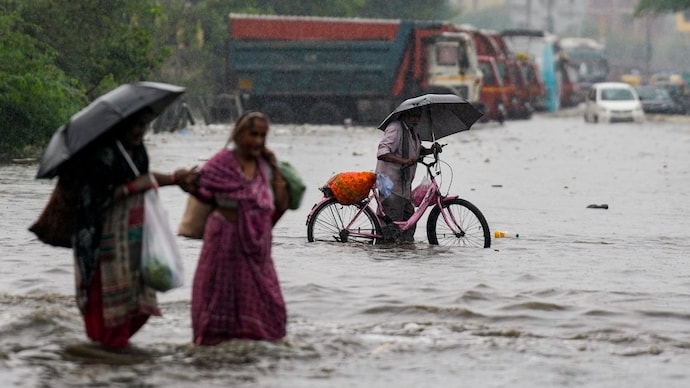
After a relentless downpour over Meghalaya on July 12, the India Meteorological Department (IMD) says east India's skies are not done yet.
In its latest advisory, the IMD has warned of heavy to very heavy rainfall over Northeast India, West Bengal and Bihar during the next two to three days. East Uttar Pradesh is likely to receive isolated heavy rainfall over the next four to five days.
The weather office has its own dictionary for rain. Heavy rainfall means 7 to 11 cm of rain in a day. Very heavy means 12 to 20 cm. Extremely heavy is anything at or above 21 cm, the category Mawkyrwat has already breached.
The downpour is not confined to the hills. Bansgaon in Gorakhpur, East Uttar Pradesh, recorded 17 cm in the same 24-hour window. Siwan in Bihar logged 8 cm, and Pundibari in Sub-Himalayan West Bengal received 9 cm.
WHY IS IT RAINING SO HEAVILY IN NORTHEAST INDIA?
Two atmospheric machines are at work. The first is the monsoon trough, an elongated belt of low pressure that stretches across the country like a conveyor belt for rain. Its eastern end is currently sitting north of its usual position, steering moisture towards the eastern and northeastern states.
The second is a set of cyclonic circulations, which are rotating columns of air a few kilometres above the ground. These are currently spinning over northeast Bihar, south Bangladesh and northeast Assam, pulling in moisture from the Bay of Bengal and wringing it out as rain.
WHICH AREAS FACE FLOODS AND LANDSLIDES?
The IMD has flagged a low to moderate flash flood risk over parts of Assam and Meghalaya, including the Garo, Khasi and Jaintia Hills and Cachar, till around midday on July 13. Landslides and mudslides are possible in the hilly terrain of Meghalaya, Assam, Arunachal Pradesh and Sub-Himalayan West Bengal and Sikkim.
In the plains, expect waterlogged roads, closed underpasses and slower commutes. Thunderstorms with gusty winds of 40 to 50 kmph, gusting to 60 kmph, are likely over Bengal and Bihar through the week. Farmers in Assam, Bengal, Bihar and East Uttar Pradesh have been advised to drain their rice, maize, vegetable and jute fields to prevent crops from drowning.
WHAT SHOULD YOU DO DURING THE HEAVY RAIN ALERT?
The northwest plains, west-central India and the southern peninsula are expected to stay largely subdued for the next six to seven days.
The monsoon is playing favourites this week. The east is its chosen one.
After a relentless downpour over Meghalaya on July 12, the India Meteorological Department (IMD) says east India's skies are not done yet.
In its latest advisory, the IMD has warned of heavy to very heavy rainfall over Northeast India, West Bengal and Bihar during the next two to three days. East Uttar Pradesh is likely to receive isolated heavy rainfall over the next four to five days.
The weather office has its own dictionary for rain. Heavy rainfall means 7 to 11 cm of rain in a day. Very heavy means 12 to 20 cm. Extremely heavy is anything at or above 21 cm, the category Mawkyrwat has already breached.
The downpour is not confined to the hills. Bansgaon in Gorakhpur, East Uttar Pradesh, recorded 17 cm in the same 24-hour window. Siwan in Bihar logged 8 cm, and Pundibari in Sub-Himalayan West Bengal received 9 cm.
WHY IS IT RAINING SO HEAVILY IN NORTHEAST INDIA?
Two atmospheric machines are at work. The first is the monsoon trough, an elongated belt of low pressure that stretches across the country like a conveyor belt for rain. Its eastern end is currently sitting north of its usual position, steering moisture towards the eastern and northeastern states.
The second is a set of cyclonic circulations, which are rotating columns of air a few kilometres above the ground. These are currently spinning over northeast Bihar, south Bangladesh and northeast Assam, pulling in moisture from the Bay of Bengal and wringing it out as rain.
WHICH AREAS FACE FLOODS AND LANDSLIDES?
The IMD has flagged a low to moderate flash flood risk over parts of Assam and Meghalaya, including the Garo, Khasi and Jaintia Hills and Cachar, till around midday on July 13. Landslides and mudslides are possible in the hilly terrain of Meghalaya, Assam, Arunachal Pradesh and Sub-Himalayan West Bengal and Sikkim.
In the plains, expect waterlogged roads, closed underpasses and slower commutes. Thunderstorms with gusty winds of 40 to 50 kmph, gusting to 60 kmph, are likely over Bengal and Bihar through the week. Farmers in Assam, Bengal, Bihar and East Uttar Pradesh have been advised to drain their rice, maize, vegetable and jute fields to prevent crops from drowning.
WHAT SHOULD YOU DO DURING THE HEAVY RAIN ALERT?
The northwest plains, west-central India and the southern peninsula are expected to stay largely subdued for the next six to seven days.
The monsoon is playing favourites this week. The east is its chosen one.

