India's worst monsoon since 2015 could be here. El Nino puts odds at 60%
IMD has put the probability of a deficient 2026 monsoon at 60 per cent, nearly four times the historical odds, as El Nino develops in the Pacific and the Indian Ocean offers no counterbalancing force. The forecast, which has already worsened since April, could make 2026 India's driest monsoon in over a decade.
For two years in a row, India's monsoon delivered. In 2024 and 2025, the rains came in above normal, reservoirs filled, and farmers got back-to-back good harvests. In 2026, that run is over.
On May 29, the India Meteorological Department (IMD) confirmed that this year's southwest monsoon, the seasonal rain system that runs from June to September and delivers nearly 70 per cent of the country's annual rainfall, is expected to reach only 90 per cent of what scientists consider normal.
If the forecast holds, 2026 would be India's driest monsoon in over a decade. The last time the country recorded a truly deficient monsoon, which means rainfall that fell below 90 per cent of normal, was 2015. That year, large parts of India faced severe drought, crop failures, and acute water stress.
That figure alone would make 2026 potentially the driest monsoon in over a decade. But the number that should stop anyone in their tracks is this: the probability of an outright deficient monsoon, which means rainfall that falls below even that already-low threshold, now stands at 60 per cent.
The historical odds of such a bad season in any given year are 16 per cent. IMD has nearly quadrupled them in a single forecast.
And the force driving all of this, El Nino, has not even reached full strength yet.
WHAT IS EL NINO?
Think of the tropical Pacific Ocean as a giant heat engine. Under normal conditions, strong east-to-west winds push warm surface water westward toward Indonesia and Australia, while cold, nutrient-rich water rises up from the deep ocean along the coast of South America to take its place.
This entire system of wind and ocean circulation is called the Walker Circulation, named after British meteorologist Sir Gilbert Walker who first described it in the early 20th century. It is one of the key engines that keeps the Indian monsoon running on time and in force.
El Nino is what happens when that engine stalls. The winds weaken. Warm water drifts back eastward toward South America. The cold upwelling is suppressed.
A large pool of unusually warm ocean surface temperatures builds across the central and eastern Pacific, and the effects travel outward across the globe, shifting rainfall patterns, rerouting jet streams, and in India's case, choking off the monsoon.
The mechanism is straightforward. The Indian monsoon is powered by a temperature contrast: as the subcontinent heats up each summer, moist air rushes in from the Indian Ocean to fill the rising column of warm air over land, and that is what brings the rain.
El Nino disrupts this by pulling the atmosphere's areas of convection, the rising columns of warm, moisture-laden air that generate clouds and rainfall, away from South Asia and toward the central Pacific instead.
Less moisture reaches India. Less rain falls. Historically, roughly 60 per cent of El Nino years between 1951 and 2022 saw below-average monsoon rainfall across the country.
THE WORST IS STILL TO COME
According to IMD's updated long-range forecast issued on May 29, the Pacific is currently transitioning from neutral conditions toward El Nino. The department's own climate models confirm that El Nino conditions are likely to develop and intensify during the monsoon season itself.
That timing is everything. The monsoon is not a single event. It is a four-month system, and its final month, September, is when standing crops are at their most vulnerable.
During the grain-filling stage, when paddy and other kharif crops convert accumulated nutrients into actual grain, sustained rainfall is not optional. An El Nino that arrives weak and intensifies as the season progresses, peaking just as September begins, is the worst possible sequence for Indian agriculture.
India is not alone in sounding the alarm. Australia's Bureau of Meteorology has projected that El Nino conditions could emerge as early as June. China's National Climate Centre has reported that Pacific warming has already entered an El Nino phase and is expected to strengthen in the months ahead.
Nasa, analysing data from the Sentinel-6 Michael Freilich satellite, which maps the height of the entire ocean surface every ten days, has detected a large mass of warm water building beneath the Pacific, precisely the kind of subsurface heat reservoir that scientists recognise as a reliable precursor to El Nino formation.
NO SAFETY NET FROM THE INDIAN OCEAN
In some El Nino years, India has been shielded by a phenomenon called the Indian Ocean Dipole, or IOD.
Picture it as a temperature see-saw sitting across the Indian Ocean: when the western end runs warmer than the eastern end, a positive IOD develops, driving additional moisture toward the subcontinent and partially neutralising El Nino's drying effect.
This is precisely what saved India's 1997-98 monsoon, when a strongly positive IOD counteracted one of the strongest El Nino events on record and delivered near-normal rainfall to the country regardless.
This year, IMD's models show IOD conditions are neutral and are expected to remain so through the entire monsoon season. There is no safety net. Whatever El Nino does to the Pacific, the Indian Ocean will not push back.
WHO GETS HIT HARDEST?
IMD's regional breakdown offers little comfort. The northeast is the only broad zone expected to see near-normal rainfall, between 94 and 106 per cent of the long-period average.
Central India, south peninsular India, and northwest India are all forecast to receive below-normal rains. The northwest could receive as little as 92 per cent of normal.
The sharpest concern is what IMD calls the Monsoon Core Zone: a wide band of states stretching from Gujarat in the west to Odisha in the east, covering the bulk of the country's rainfed farmland.
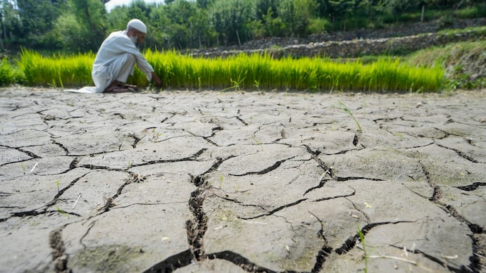
This entire zone is forecast to receive below-normal rainfall. Around 60 per cent of India's farmers work without any irrigation backup. For them, there is no borewell to fall back on, no canal network to draw from. What the sky delivers between June and September is the entire agricultural year.
A monsoon deficit across the Core Zone means lower yields of kharif crops: rice, pulses, oilseeds, and coarse cereals sown at the start of summer and harvested in autumn.
Food makes up roughly 37 per cent of India's inflation basket. When harvests shrink, grocery prices climb, and the burden lands the hardest on the households least able to absorb it.
IS THERE ANY REASON FOR HOPE?
El Nino is not a guarantee of drought. Five of the 17 El Nino events recorded between 1951 and 2022 brought normal or above-average rainfall to India despite the Pacific warming.
Monsoon systems are driven by many variables simultaneously, and IMD will continue issuing updated regional forecasts as the season unfolds.
The next bulletin, covering July rainfall, is expected in the last week of June 2026.
But the numbers standing today are hard to look past. A 60 per cent chance of a deficient monsoon. A historical baseline of 16 per cent. An El Nino still building in strength. An Indian Ocean with nothing to offer in return. And a forecast that has already been revised downward once since April.
The rains may still come. But for the first time in over a decade, the question is no longer whether India's monsoon will be good. It is how bad it will get.
For two years in a row, India's monsoon delivered. In 2024 and 2025, the rains came in above normal, reservoirs filled, and farmers got back-to-back good harvests. In 2026, that run is over.
On May 29, the India Meteorological Department (IMD) confirmed that this year's southwest monsoon, the seasonal rain system that runs from June to September and delivers nearly 70 per cent of the country's annual rainfall, is expected to reach only 90 per cent of what scientists consider normal.
If the forecast holds, 2026 would be India's driest monsoon in over a decade. The last time the country recorded a truly deficient monsoon, which means rainfall that fell below 90 per cent of normal, was 2015. That year, large parts of India faced severe drought, crop failures, and acute water stress.
That figure alone would make 2026 potentially the driest monsoon in over a decade. But the number that should stop anyone in their tracks is this: the probability of an outright deficient monsoon, which means rainfall that falls below even that already-low threshold, now stands at 60 per cent.
The historical odds of such a bad season in any given year are 16 per cent. IMD has nearly quadrupled them in a single forecast.
And the force driving all of this, El Nino, has not even reached full strength yet.
WHAT IS EL NINO?
Think of the tropical Pacific Ocean as a giant heat engine. Under normal conditions, strong east-to-west winds push warm surface water westward toward Indonesia and Australia, while cold, nutrient-rich water rises up from the deep ocean along the coast of South America to take its place.
This entire system of wind and ocean circulation is called the Walker Circulation, named after British meteorologist Sir Gilbert Walker who first described it in the early 20th century. It is one of the key engines that keeps the Indian monsoon running on time and in force.
El Nino is what happens when that engine stalls. The winds weaken. Warm water drifts back eastward toward South America. The cold upwelling is suppressed.
A large pool of unusually warm ocean surface temperatures builds across the central and eastern Pacific, and the effects travel outward across the globe, shifting rainfall patterns, rerouting jet streams, and in India's case, choking off the monsoon.
The mechanism is straightforward. The Indian monsoon is powered by a temperature contrast: as the subcontinent heats up each summer, moist air rushes in from the Indian Ocean to fill the rising column of warm air over land, and that is what brings the rain.
El Nino disrupts this by pulling the atmosphere's areas of convection, the rising columns of warm, moisture-laden air that generate clouds and rainfall, away from South Asia and toward the central Pacific instead.
Less moisture reaches India. Less rain falls. Historically, roughly 60 per cent of El Nino years between 1951 and 2022 saw below-average monsoon rainfall across the country.
THE WORST IS STILL TO COME
According to IMD's updated long-range forecast issued on May 29, the Pacific is currently transitioning from neutral conditions toward El Nino. The department's own climate models confirm that El Nino conditions are likely to develop and intensify during the monsoon season itself.
That timing is everything. The monsoon is not a single event. It is a four-month system, and its final month, September, is when standing crops are at their most vulnerable.
During the grain-filling stage, when paddy and other kharif crops convert accumulated nutrients into actual grain, sustained rainfall is not optional. An El Nino that arrives weak and intensifies as the season progresses, peaking just as September begins, is the worst possible sequence for Indian agriculture.
India is not alone in sounding the alarm. Australia's Bureau of Meteorology has projected that El Nino conditions could emerge as early as June. China's National Climate Centre has reported that Pacific warming has already entered an El Nino phase and is expected to strengthen in the months ahead.
Nasa, analysing data from the Sentinel-6 Michael Freilich satellite, which maps the height of the entire ocean surface every ten days, has detected a large mass of warm water building beneath the Pacific, precisely the kind of subsurface heat reservoir that scientists recognise as a reliable precursor to El Nino formation.
NO SAFETY NET FROM THE INDIAN OCEAN
In some El Nino years, India has been shielded by a phenomenon called the Indian Ocean Dipole, or IOD.
Picture it as a temperature see-saw sitting across the Indian Ocean: when the western end runs warmer than the eastern end, a positive IOD develops, driving additional moisture toward the subcontinent and partially neutralising El Nino's drying effect.
This is precisely what saved India's 1997-98 monsoon, when a strongly positive IOD counteracted one of the strongest El Nino events on record and delivered near-normal rainfall to the country regardless.
This year, IMD's models show IOD conditions are neutral and are expected to remain so through the entire monsoon season. There is no safety net. Whatever El Nino does to the Pacific, the Indian Ocean will not push back.
WHO GETS HIT HARDEST?
IMD's regional breakdown offers little comfort. The northeast is the only broad zone expected to see near-normal rainfall, between 94 and 106 per cent of the long-period average.
Central India, south peninsular India, and northwest India are all forecast to receive below-normal rains. The northwest could receive as little as 92 per cent of normal.
The sharpest concern is what IMD calls the Monsoon Core Zone: a wide band of states stretching from Gujarat in the west to Odisha in the east, covering the bulk of the country's rainfed farmland.
This entire zone is forecast to receive below-normal rainfall. Around 60 per cent of India's farmers work without any irrigation backup. For them, there is no borewell to fall back on, no canal network to draw from. What the sky delivers between June and September is the entire agricultural year.
A monsoon deficit across the Core Zone means lower yields of kharif crops: rice, pulses, oilseeds, and coarse cereals sown at the start of summer and harvested in autumn.
Food makes up roughly 37 per cent of India's inflation basket. When harvests shrink, grocery prices climb, and the burden lands the hardest on the households least able to absorb it.
IS THERE ANY REASON FOR HOPE?
El Nino is not a guarantee of drought. Five of the 17 El Nino events recorded between 1951 and 2022 brought normal or above-average rainfall to India despite the Pacific warming.
Monsoon systems are driven by many variables simultaneously, and IMD will continue issuing updated regional forecasts as the season unfolds.
The next bulletin, covering July rainfall, is expected in the last week of June 2026.
But the numbers standing today are hard to look past. A 60 per cent chance of a deficient monsoon. A historical baseline of 16 per cent. An El Nino still building in strength. An Indian Ocean with nothing to offer in return. And a forecast that has already been revised downward once since April.
The rains may still come. But for the first time in over a decade, the question is no longer whether India's monsoon will be good. It is how bad it will get.