This is not a Van Gogh painting: Nasa turns ocean currents into stunning visuals
What looks like a work of digital art is actually built by Nasa, using years of satellite observations and ocean measurements, showing how oceans influence weather, climate and marine life across the planet. Here's how
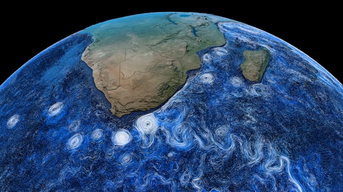
Space agency Nasa has unveiled one of its most breathtaking visualisations yet, transforming years of scientific observations and data into a beautiful portrait of Earth's restless oceans.
Powered by real-world data from satellites and the sea, the animation reveals the hidden highways of water that constantly shape the planet's weather, climate, and marine ecosystems.
BRINGING OCEAN'S HIDDEN HIGHWAYS TO LIFE
The new data visualisation, called Perpetual Ocean 2, offers a rare look at how water moves across the globe in an endless dance.
Delicate white streaks trace the fastest surface currents, while deep blue hues uncover slower flows beneath the surface.
The result is a display of giant ocean "rivers," swirling eddies stretching thousands of kilometres across, and mighty currents such as the Gulf Stream transporting warm tropical waters from the Gulf of Mexico toward Europe.
Far from being an artist's interpretation, the animation is built on Nasa's Estimating the Circulation and Climate of the Ocean (ECCO) model.
ECCO combines observations from satellites, floating buoys, and a wide network of ocean-monitoring instruments with the laws of physics to recreate the most accurate picture possible of how the world's oceans have behaved over decades.
WHY ARE OCEAN CURRENTS IMPORTANT?
Although hidden beneath the waves, ocean currents play a vital role in keeping Earth's climate in balance.
Acting like a vast global conveyor belt, they transport heat from the equator toward the poles, helping regulate weather patterns and regional climates. They also carry nutrients that sustain marine life and help absorb and redistribute carbon dioxide.
One of the best-known examples is the Gulf Stream, whose steady flow of warm water keeps much of northern Europe significantly milder than it would otherwise be.
A BIG LEAP FROM THE 2011 ORIGINAL
Nasa's original Perpetual Ocean animation, released in 2011, became widely popular for revealing surface ocean currents.
The new version takes that idea much further by peering beneath the surface to show the complex, three-dimensional movement of ocean waters.
Released in early 2025 by Nasa's Scientific Visualisation Studio, Perpetual Ocean 2 is based on data collected between 2021 and 2023 and reflects years of improvements to the ECCO model.
Scientists have admitted that visualisations like these are more than just beautiful; they are essential tools for understanding climate change, rising sea levels, and shifting marine ecosystems.
For everyone else, they offer a fascinating reminder that beneath the seemingly calm surface, Earth's oceans are in constant motion, tirelessly looking after the world around us.
Space agency Nasa has unveiled one of its most breathtaking visualisations yet, transforming years of scientific observations and data into a beautiful portrait of Earth's restless oceans.
Powered by real-world data from satellites and the sea, the animation reveals the hidden highways of water that constantly shape the planet's weather, climate, and marine ecosystems.
BRINGING OCEAN'S HIDDEN HIGHWAYS TO LIFE
The new data visualisation, called Perpetual Ocean 2, offers a rare look at how water moves across the globe in an endless dance.
Delicate white streaks trace the fastest surface currents, while deep blue hues uncover slower flows beneath the surface.
The result is a display of giant ocean "rivers," swirling eddies stretching thousands of kilometres across, and mighty currents such as the Gulf Stream transporting warm tropical waters from the Gulf of Mexico toward Europe.
Far from being an artist's interpretation, the animation is built on Nasa's Estimating the Circulation and Climate of the Ocean (ECCO) model.
ECCO combines observations from satellites, floating buoys, and a wide network of ocean-monitoring instruments with the laws of physics to recreate the most accurate picture possible of how the world's oceans have behaved over decades.
WHY ARE OCEAN CURRENTS IMPORTANT?
Although hidden beneath the waves, ocean currents play a vital role in keeping Earth's climate in balance.
Acting like a vast global conveyor belt, they transport heat from the equator toward the poles, helping regulate weather patterns and regional climates. They also carry nutrients that sustain marine life and help absorb and redistribute carbon dioxide.
One of the best-known examples is the Gulf Stream, whose steady flow of warm water keeps much of northern Europe significantly milder than it would otherwise be.
A BIG LEAP FROM THE 2011 ORIGINAL
Nasa's original Perpetual Ocean animation, released in 2011, became widely popular for revealing surface ocean currents.
The new version takes that idea much further by peering beneath the surface to show the complex, three-dimensional movement of ocean waters.
Released in early 2025 by Nasa's Scientific Visualisation Studio, Perpetual Ocean 2 is based on data collected between 2021 and 2023 and reflects years of improvements to the ECCO model.
Scientists have admitted that visualisations like these are more than just beautiful; they are essential tools for understanding climate change, rising sea levels, and shifting marine ecosystems.
For everyone else, they offer a fascinating reminder that beneath the seemingly calm surface, Earth's oceans are in constant motion, tirelessly looking after the world around us.
Space agency Nasa has unveiled one of its most breathtaking visualisations yet, transforming years of scientific observations and data into a beautiful portrait of Earth's restless oceans.
Powered by real-world data from satellites and the sea, the animation reveals the hidden highways of water that constantly shape the planet's weather, climate, and marine ecosystems.
BRINGING OCEAN'S HIDDEN HIGHWAYS TO LIFE
The new data visualisation, called Perpetual Ocean 2, offers a rare look at how water moves across the globe in an endless dance.
Delicate white streaks trace the fastest surface currents, while deep blue hues uncover slower flows beneath the surface.
The result is a display of giant ocean "rivers," swirling eddies stretching thousands of kilometres across, and mighty currents such as the Gulf Stream transporting warm tropical waters from the Gulf of Mexico toward Europe.
Far from being an artist's interpretation, the animation is built on Nasa's Estimating the Circulation and Climate of the Ocean (ECCO) model.
ECCO combines observations from satellites, floating buoys, and a wide network of ocean-monitoring instruments with the laws of physics to recreate the most accurate picture possible of how the world's oceans have behaved over decades.
WHY ARE OCEAN CURRENTS IMPORTANT?
Although hidden beneath the waves, ocean currents play a vital role in keeping Earth's climate in balance.
Acting like a vast global conveyor belt, they transport heat from the equator toward the poles, helping regulate weather patterns and regional climates. They also carry nutrients that sustain marine life and help absorb and redistribute carbon dioxide.
One of the best-known examples is the Gulf Stream, whose steady flow of warm water keeps much of northern Europe significantly milder than it would otherwise be.
A BIG LEAP FROM THE 2011 ORIGINAL
Nasa's original Perpetual Ocean animation, released in 2011, became widely popular for revealing surface ocean currents.
The new version takes that idea much further by peering beneath the surface to show the complex, three-dimensional movement of ocean waters.
Released in early 2025 by Nasa's Scientific Visualisation Studio, Perpetual Ocean 2 is based on data collected between 2021 and 2023 and reflects years of improvements to the ECCO model.
Scientists have admitted that visualisations like these are more than just beautiful; they are essential tools for understanding climate change, rising sea levels, and shifting marine ecosystems.
For everyone else, they offer a fascinating reminder that beneath the seemingly calm surface, Earth's oceans are in constant motion, tirelessly looking after the world around us.

