Deep Depression weakens, no new vortex over Bay of Bengal, Arabian Sea: Isro images
Isro satellite images and IMD data confirm the Deep Depression is weakening as it moves inland, with no new vortex forming over the Bay of Bengal or Arabian Sea. Here is what it means for monsoon rain in the coming days.
The monsoon has kept large parts of India under rain today. It might sound like several storms are converging at once, but the satellite picture and the India Meteorological Department (IMD)’s own tracking say otherwise.
It is still one system, moving at a steady, unspectacular 12 kilometres an hour, and it is now deep enough inland that neither the Bay of Bengal nor the Arabian Sea is currently host to anything resembling a storm.
WHAT DOES THIS MORNING'S ISRO SATELLITE IMAGE SHOW?
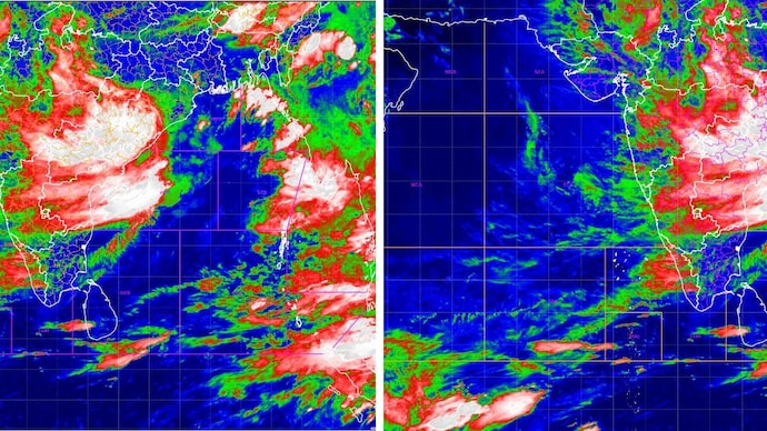
The infrared picture, captured by INSAT-3DR, a weather satellite built by the Indian Space Research Organisation (Isro) and operated by the IMD, was taken between 4:45 am and 5:12 am IST today.
It reads temperature rather than light. White and pale pink mark cloud tops colder than minus 70 degrees Celsius, the sign of the tallest, most intense thunderstorms; green and red mark milder clouds below that.
Today's frame shows two features. A broad white and pink mass sits inland over the Chhattisgarh, Odisha and Madhya Pradesh belt, well away from the Bay of Bengal, where the system originally formed at sea, and that is the Deep Depression's rain engine.
A second, separate bright patch has built up further west over Maharashtra, close to the Arabian Sea coast, produced by the same system pulling in moisture from the Arabian Sea and forcing it up against the Western Ghats, a process called orographic lift, rather than by any new storm forming at sea.
WHERE EXACTLY IS THE DEPRESSION NOW, AND HOW FAST IS IT MOVING?
According to the IMD, the Deep Depression that began over the northwest Bay of Bengal is moving west-northwest at 12 kilometres an hour, weakening gradually as it goes. ‘
That slow, grinding pace is normal. Monsoon depressions rarely race across the map. They crawl, and it is that crawl which lets them dump so much rain over any one place.
IS A NEW VORTEX FORMING OVER THE BAY OF BENGAL?
No. The northern Bay, where this depression was born four days ago, has gone quiet in today's image, showing only broken, scattered cloud rather than the tight, spinning mass that marks an organised low.
A vortex, meaning a mass of air rotating around a low-pressure centre, needs a closed circulation to count as a genuine system, and there isn't one out there this morning.
It helps here to keep the terms apart, because they get used loosely. A cyclonic circulation is simply air turning anticlockwise around low pressure, the loosest and weakest stage, often not even visible at the surface.
If that circulation tightens and organises itself with a defined centre, it becomes a depression, then a Deep Depression as its winds cross 51 kilometres an hour, and eventually a cyclone if it strengthens further still out at sea.
A vortex is the broader, more general term for any of these rotating air masses, whichever stage they happen to be at. So every depression is a vortex, but not every vortex is a depression, and what the Bay shows this morning is neither. There isn't a closed circulation there at all.
WHAT IS HAPPENING OVER THE ARABIAN SEA TODAY?
The central and northern Arabian Sea remain mostly clear in today's image, shown in dark blue, meaning warm sea and little cloud above it.
There is cloud along India's west coast, feeding monsoon rain there, and a band of storms near the equator that belongs to the Intertropical Convergence Zone, or ITCZ, the permanent belt of showers that circles the globe where winds from the northern and southern hemispheres meet.
There is one small addendum worth mentioning. Earlier this week, forecasters had flagged a weak upper-air cyclonic circulation over the east-central Arabian Sea, sitting a few kilometres above the surface rather than at ground level.
The IMD's own bulletin today describes that feature as having become less marked, in other words, weaker than before, not stronger. It was never a depression or a storm, only a subtle circulation aloft, and it is fading rather than building.
WHAT DOES THIS MEAN FOR MONSOON RAIN GOING FORWARD?
It means the current spell of rain has an identifiable end point, even if it is not immediate.
As the depression weakens further over the next few days, the intensity of rain will ease from its current peak, though the moisture it has already pulled inland will keep skies cloudy and showers frequent across large parts of the country a while longer.
With no new vortex building over either sea, there is nothing at present to hand the baton to once this system fades.
WHAT SHOULD PEOPLE IN THE RAIN'S PATH DO?
The advice remains unchanged from earlier this week. Stay off the water in the northwest Bay of Bengal. Avoid sheltering under trees during lightning. Keep an eye on local flood warnings in areas where soils are already saturated after days of rain.
The story today is not a new storm. It is the same one, older, slower and further inland, still carrying enough moisture to keep large parts of the country under watch, while the seas it came from settle back into an ordinary monsoon calm.
The monsoon has kept large parts of India under rain today. It might sound like several storms are converging at once, but the satellite picture and the India Meteorological Department (IMD)’s own tracking say otherwise.
It is still one system, moving at a steady, unspectacular 12 kilometres an hour, and it is now deep enough inland that neither the Bay of Bengal nor the Arabian Sea is currently host to anything resembling a storm.
WHAT DOES THIS MORNING'S ISRO SATELLITE IMAGE SHOW?
The infrared picture, captured by INSAT-3DR, a weather satellite built by the Indian Space Research Organisation (Isro) and operated by the IMD, was taken between 4:45 am and 5:12 am IST today.
It reads temperature rather than light. White and pale pink mark cloud tops colder than minus 70 degrees Celsius, the sign of the tallest, most intense thunderstorms; green and red mark milder clouds below that.
Today's frame shows two features. A broad white and pink mass sits inland over the Chhattisgarh, Odisha and Madhya Pradesh belt, well away from the Bay of Bengal, where the system originally formed at sea, and that is the Deep Depression's rain engine.
A second, separate bright patch has built up further west over Maharashtra, close to the Arabian Sea coast, produced by the same system pulling in moisture from the Arabian Sea and forcing it up against the Western Ghats, a process called orographic lift, rather than by any new storm forming at sea.
WHERE EXACTLY IS THE DEPRESSION NOW, AND HOW FAST IS IT MOVING?
According to the IMD, the Deep Depression that began over the northwest Bay of Bengal is moving west-northwest at 12 kilometres an hour, weakening gradually as it goes. ‘
That slow, grinding pace is normal. Monsoon depressions rarely race across the map. They crawl, and it is that crawl which lets them dump so much rain over any one place.
IS A NEW VORTEX FORMING OVER THE BAY OF BENGAL?
No. The northern Bay, where this depression was born four days ago, has gone quiet in today's image, showing only broken, scattered cloud rather than the tight, spinning mass that marks an organised low.
A vortex, meaning a mass of air rotating around a low-pressure centre, needs a closed circulation to count as a genuine system, and there isn't one out there this morning.
It helps here to keep the terms apart, because they get used loosely. A cyclonic circulation is simply air turning anticlockwise around low pressure, the loosest and weakest stage, often not even visible at the surface.
If that circulation tightens and organises itself with a defined centre, it becomes a depression, then a Deep Depression as its winds cross 51 kilometres an hour, and eventually a cyclone if it strengthens further still out at sea.
A vortex is the broader, more general term for any of these rotating air masses, whichever stage they happen to be at. So every depression is a vortex, but not every vortex is a depression, and what the Bay shows this morning is neither. There isn't a closed circulation there at all.
WHAT IS HAPPENING OVER THE ARABIAN SEA TODAY?
The central and northern Arabian Sea remain mostly clear in today's image, shown in dark blue, meaning warm sea and little cloud above it.
There is cloud along India's west coast, feeding monsoon rain there, and a band of storms near the equator that belongs to the Intertropical Convergence Zone, or ITCZ, the permanent belt of showers that circles the globe where winds from the northern and southern hemispheres meet.
There is one small addendum worth mentioning. Earlier this week, forecasters had flagged a weak upper-air cyclonic circulation over the east-central Arabian Sea, sitting a few kilometres above the surface rather than at ground level.
The IMD's own bulletin today describes that feature as having become less marked, in other words, weaker than before, not stronger. It was never a depression or a storm, only a subtle circulation aloft, and it is fading rather than building.
WHAT DOES THIS MEAN FOR MONSOON RAIN GOING FORWARD?
It means the current spell of rain has an identifiable end point, even if it is not immediate.
As the depression weakens further over the next few days, the intensity of rain will ease from its current peak, though the moisture it has already pulled inland will keep skies cloudy and showers frequent across large parts of the country a while longer.
With no new vortex building over either sea, there is nothing at present to hand the baton to once this system fades.
WHAT SHOULD PEOPLE IN THE RAIN'S PATH DO?
The advice remains unchanged from earlier this week. Stay off the water in the northwest Bay of Bengal. Avoid sheltering under trees during lightning. Keep an eye on local flood warnings in areas where soils are already saturated after days of rain.
The story today is not a new storm. It is the same one, older, slower and further inland, still carrying enough moisture to keep large parts of the country under watch, while the seas it came from settle back into an ordinary monsoon calm.
The monsoon has kept large parts of India under rain today. It might sound like several storms are converging at once, but the satellite picture and the India Meteorological Department (IMD)’s own tracking say otherwise.
It is still one system, moving at a steady, unspectacular 12 kilometres an hour, and it is now deep enough inland that neither the Bay of Bengal nor the Arabian Sea is currently host to anything resembling a storm.
WHAT DOES THIS MORNING'S ISRO SATELLITE IMAGE SHOW?
The infrared picture, captured by INSAT-3DR, a weather satellite built by the Indian Space Research Organisation (Isro) and operated by the IMD, was taken between 4:45 am and 5:12 am IST today.
It reads temperature rather than light. White and pale pink mark cloud tops colder than minus 70 degrees Celsius, the sign of the tallest, most intense thunderstorms; green and red mark milder clouds below that.
Today's frame shows two features. A broad white and pink mass sits inland over the Chhattisgarh, Odisha and Madhya Pradesh belt, well away from the Bay of Bengal, where the system originally formed at sea, and that is the Deep Depression's rain engine.
A second, separate bright patch has built up further west over Maharashtra, close to the Arabian Sea coast, produced by the same system pulling in moisture from the Arabian Sea and forcing it up against the Western Ghats, a process called orographic lift, rather than by any new storm forming at sea.
WHERE EXACTLY IS THE DEPRESSION NOW, AND HOW FAST IS IT MOVING?
According to the IMD, the Deep Depression that began over the northwest Bay of Bengal is moving west-northwest at 12 kilometres an hour, weakening gradually as it goes. ‘
That slow, grinding pace is normal. Monsoon depressions rarely race across the map. They crawl, and it is that crawl which lets them dump so much rain over any one place.
IS A NEW VORTEX FORMING OVER THE BAY OF BENGAL?
No. The northern Bay, where this depression was born four days ago, has gone quiet in today's image, showing only broken, scattered cloud rather than the tight, spinning mass that marks an organised low.
A vortex, meaning a mass of air rotating around a low-pressure centre, needs a closed circulation to count as a genuine system, and there isn't one out there this morning.
It helps here to keep the terms apart, because they get used loosely. A cyclonic circulation is simply air turning anticlockwise around low pressure, the loosest and weakest stage, often not even visible at the surface.
If that circulation tightens and organises itself with a defined centre, it becomes a depression, then a Deep Depression as its winds cross 51 kilometres an hour, and eventually a cyclone if it strengthens further still out at sea.
A vortex is the broader, more general term for any of these rotating air masses, whichever stage they happen to be at. So every depression is a vortex, but not every vortex is a depression, and what the Bay shows this morning is neither. There isn't a closed circulation there at all.
WHAT IS HAPPENING OVER THE ARABIAN SEA TODAY?
The central and northern Arabian Sea remain mostly clear in today's image, shown in dark blue, meaning warm sea and little cloud above it.
There is cloud along India's west coast, feeding monsoon rain there, and a band of storms near the equator that belongs to the Intertropical Convergence Zone, or ITCZ, the permanent belt of showers that circles the globe where winds from the northern and southern hemispheres meet.
There is one small addendum worth mentioning. Earlier this week, forecasters had flagged a weak upper-air cyclonic circulation over the east-central Arabian Sea, sitting a few kilometres above the surface rather than at ground level.
The IMD's own bulletin today describes that feature as having become less marked, in other words, weaker than before, not stronger. It was never a depression or a storm, only a subtle circulation aloft, and it is fading rather than building.
WHAT DOES THIS MEAN FOR MONSOON RAIN GOING FORWARD?
It means the current spell of rain has an identifiable end point, even if it is not immediate.
As the depression weakens further over the next few days, the intensity of rain will ease from its current peak, though the moisture it has already pulled inland will keep skies cloudy and showers frequent across large parts of the country a while longer.
With no new vortex building over either sea, there is nothing at present to hand the baton to once this system fades.
WHAT SHOULD PEOPLE IN THE RAIN'S PATH DO?
The advice remains unchanged from earlier this week. Stay off the water in the northwest Bay of Bengal. Avoid sheltering under trees during lightning. Keep an eye on local flood warnings in areas where soils are already saturated after days of rain.
The story today is not a new storm. It is the same one, older, slower and further inland, still carrying enough moisture to keep large parts of the country under watch, while the seas it came from settle back into an ordinary monsoon calm.

