
Why the Ganga has swollen at Patna despite below-normal rainfall

It was not one river or the story of a wet monsoon. It was a junction flood: several rivers rising together while the Ganga was already running high
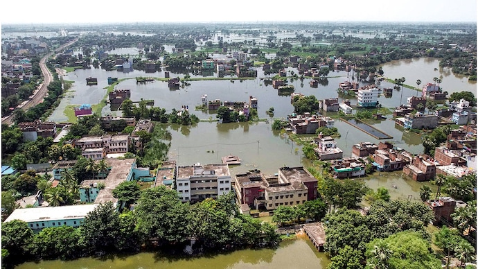

 Patna does not sit on a quiet stretch of one river. It sits at a junction. Within a few kilometres, the Ganga receives three major rivers. From the south-west, the Sone comes down and meets the Ganga at Maner, just west of Bihar’s capital city.
From the north, the Gandak comes out of Nepal through Valmikinagar and joins the Ganga at Sonepur and Hajipur, opposite Patna. From the south-east, the Punpun comes down from the Gaya-Jehanabad side and meets the Ganga at Fatuha, just east of the city.
The land here is almost flat. When large volumes of water arrive from several directions at the same time, the river’s ability to carry that onward is reduced. A channel that is already running high has less room, and less hydraulic head, to take in more water from its tributaries and move it downstream quickly. Water, therefore, backs up around the confluences and pushes levels higher upstream.
That is what happened this week. It was not a flood from one river, and it was not the story of a wet monsoon. It was a junction flood: several rivers rising together while the Ganga was already running high.
THE GANGA FROM THE WEST
By the time the Ganga reaches Patna, it is already carrying water from a huge basin. The Yamuna joins it upstream at Prayagraj. The Ghaghra joins further east near Chhapra. The river is moving towards Munger, Bhagalpur and West Bengal.
In an ordinary week, the tributaries around Patna add water and the Ganga carries that flow onward. The level rises, then falls. This week, much more water arrived while the downstream river was already high.
A river does not have to overflow everywhere for the gauge at Patna to jump. It only needs more water entering a stretch than that stretch can carry away at that moment. What should have been passed on towards the east stacked in the reach from Danapur to Fatuha. That stack is the bulge.
From Patna, the river runs east: Fatuha to Pandarak, then Barh, Hathidah (Mokama), Munger, Sultanganj, Bhagalpur, Kahalgaon and only much later Farakka and the sea.
WHY IT COULD NOT LEAVE
Two things at once. First, too much water was joining at Patna—Sone at Maner, Gandak at Hajipur, Punpun at Fatuha—while the main Ganga was already high. Second, the road out was itself full. On the same morning, the Ganga was above the danger mark at Hathidah, Munger, Bhagalpur and Kahalgaon.
Some of those gauges were at or above their own old flood records. There was no empty stretch waiting to receive Patna’s extra water. It is not that the east “refused” the water. The east was already holding a bulge of its own. Two full stretches, one flat river: the capital gauge rises.
This week’s largest contributor
The Sone rises near Amarkantak on the Madhya Pradesh-Chhattisgarh border and flows through Madhya Pradesh, Uttar Pradesh, Jharkhand and Bihar before joining the Ganga near Maner. It is the second-largest southern tributary of the Ganga after the Yamuna. Its catchment is about 69,000 sq km. This is plateau water, not Himalayan water.
The control point is the Indrapuri Barrage at Dehri-on-Sone. On September 2, the barrage passed 563,654 cusecs—the Sone’s peak this season. That is the discharge that belongs next to the broken records at Gandhi Ghat and Danapur. Officials later linked the easing of the Patna gauges to the subsequent fall in Sone discharge.
By 10 am on September 7, the same barrage was down to 133,134 cusecs and falling. The river had not vanished. The peak had moved east, towards Hathidah, Munger and Bhagalpur. What begins as a huge release on the Sone later becomes pressure further downstream. A barrage figure is a rate, not a tank. One lakh cusecs means 100,000 cubic feet of water passing a point every second.
THE PUNPUN FROM THE SOUTH-EAST
The Punpun rises in Jharkhand’s Palamu region, crosses parts of south Bihar and joins the Ganga at Fatuha. It is largely rain-fed: quiet in the dry months, quick to rise after heavy rain. Smaller streams such as the Dardha and the Morhar feed it. The Phalgu, which flows through Gaya, belongs to the same southern system. This week, the Punpun was above the danger level at Sripalpur and added pressure on low ground south of Patna. It can empty into the Ganga at Fatuha only as fast as the receiving river allows. When the Ganga is already high, that outlet is less forgiving.
GANDAK, KOSI AND OTHER RIVERS
The Gandak is born in Nepal and joins the Ganga at Sonepur-Hajipur, opposite Patna. Most of its catchment lies in Nepal. At 10 am on September 7, the Valmikinagar Barrage was passing 121,500 cusecs—well below its season’s peak of 224,000 cusecs on July 14. The river was nevertheless above danger at Dumariaghat and Hajipur. It was part of the pressure on the Ganga around Patna. It was not the largest contributor this week.
The Kosi at Birpur was at 198,150 cusecs on September 7 morning, below its July peak of 255,425 cusecs. The Bagmati, Budhi Gandak and Ghaghra were also above danger at several points. They do not all pour into Gandhi Ghat. They keep north and east Bihar wet and hold the wider Ganga system high, so water at Patna cannot leave quickly.
September changed the equation. On September 2, the Sone at Indrapuri reached 5.64 lakh cusecs. A large volume then moved towards its meeting with the Ganga at Maner. At the same time the Gandak was high at Hajipur, the Punpun was high at Fatuha, and the Ganga itself was carrying a substantial eastward flow. By September 6, four Patna gauges had crossed their previous highest flood levels. Gandhi Ghat reached 50.57 metres, five centimetres above its 2016 record. By September 7, the Sone’s discharge had fallen sharply. That eases the capital. It also means the same water is travelling downstream.
North of the Ganga the story is Himalayan. The Gandak and the Kosi bring water from Nepal. That is why north Bihar floods so often. South of the Ganga the geography is different. The Sone and the Punpun drain the plateau and southern Bihar.
This week, both sides were adding to a Ganga that was already high. That is why a monsoon that remains 27 per cent below normal overall could still push the Ganga above a 10-year mark in the state capital. The rivers have not changed. The timing has. The volume has. And none of them waits for the other to finish before joining the Ganga.
WHAT THE GOVERNMENT SAID
According to the disaster management department’s bulletin of September 7, Bihar’s own rainfall had been below normal through most of the monsoon. June recorded 103.8 mm, 36 per cent below normal. July had 227.2 mm, 33 per cent below normal. August had 190.4 mm, 29 per cent below normal. From June 1 to September 7, the state had recorded 597.4 mm, still 27 per cent below normal. September, however, had already brought 75.9 mm—45 per cent above normal for the month up to that point.
Three relatively dry months, then a wet spell. The water balance changed quickly. On September 6, the Central Water Commission found the Ganga above its previous highest flood level at four locations in Patna. Gandhi Ghat stood at 50.57 metres—five centimetres above the previous record of 50.52 metres, set on August 21, 2016. Pandarak was at 43.92 metres, 19 centimetres above its record of August 16, 2021. Danapur was at 52.63 metres, two centimetres above its record of August 15, 2021. Banka Ghat was at 49.47 metres, three centimetres above its record of August 16, 2021. The trend at all four gauges was described as stable. The river was also above the danger mark at Digha, Hathidah, Buxar, Munger, Bhagalpur and Kahalgaon.
Other rivers were above danger the same morning: the Gandak at Dumariaghat and Hajipur; the Kosi at Baltara and Kursela; the Budhi Gandak at Khagaria; the Punpun at Sripalpur; the Bagmati at Benibad; and the Ghaghra at Darauli and Gangpur.
The government had counted about 2.7 million people as affected across 13 districts—Patna, Bhojpur, Saran, Vaishali, Bhagalpur, Begusarai, Buxar, Samastipur, Munger, Katihar, Lakhisarai, Khagaria and Arwal—in 74 blocks and 423 gram panchayats. The good news is that the tap at the capital has begun to close. On September 7, the Sone at Indrapuri was down to 1.33 lakh cusecs and falling—far below the 5.64 lakh that hit Maner on September 2—and the Patna gauges, having broken their old marks, were no longer racing upward.
The concern, however, is that the flood has not ended. It has changed address. The same water is travelling east into stretches that were already above danger at Hathidah, Munger, Bhagalpur and Kahalgaon. South of the city, the Punpun still cannot empty freely at Fatuha. Another burst of rain can load a river that has only just started to pass the last peak on.
Subscribe to India Today Magazine