
Lowest rainfall in 126 years: Why is Northeast India bone dry in 2026?
Northeast India recorded its driest June in 126 years, with rainfall nearly 40 per cent below normal, according to IMD data. A weak monsoon trough, missing Bay of Bengal low pressure systems and a strengthening El Nino combined to choke off the region's rain.
")
Northeast India, usually one of the wettest regions on Earth, just recorded its driest June in 126 years. (Photo: PTI)

New Delhi,UPDATED: Jul 3, 2026 13:18 IST
Northeast India, home to some of the wettest places on Earth, has just recorded its driest June in 126 years, with rainfall crashing nearly 40 per cent below normal, India Meteorological Department (IMD) data show.
For a region where the rain usually never stops, where towns like Cherrapunji and Mawsynram hold world records for the sheer volume of water that falls from the sky, this June felt eerily quiet.
Rivers ran low, fields cracked, and farmers who normally battle floods this time of year found themselves waiting, and waiting, for clouds that simply would not break.
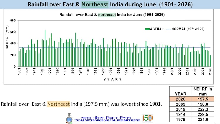
The homogenous East and Northeast India region received just 197.5 mm of rainfall in June, a deficit of 39.9 per cent compared to the normal monthly rainfall.
The previous lowest total on record was 198 mm, set way back in 2009. IMD officials say this year's shortfall was not down to one single culprit but a rare pile-up of weather factors that all pointed the same way, toward drought.
WHAT MADE THIS JUNE SO DIFFERENT FROM A NORMAL MONSOON?
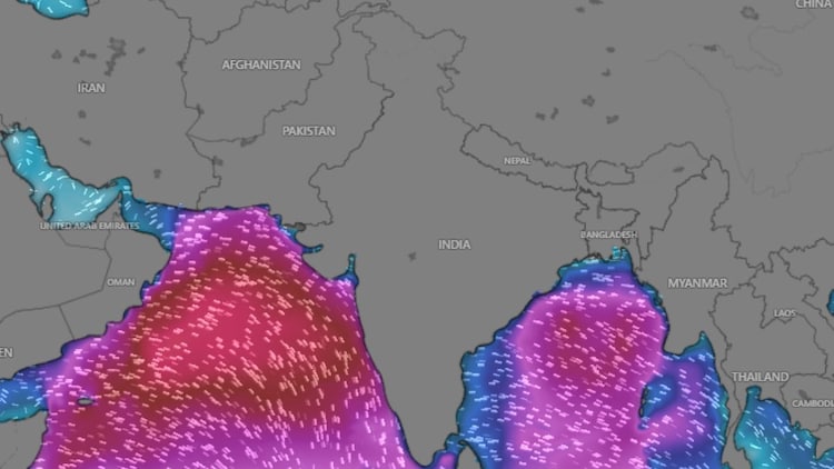
Normally, the Bay of Bengal acts like an engine room for the Northeast's monsoon, churning out low-pressure systems, essentially clusters of clouds and thunderstorms, that pull in moisture and dump it over the hills, day after day.
This year, that engine barely turned over. IMD officials attributed the deficit to weakened monsoon systems, the absence of active monsoon troughs over the Bay of Bengal, and the growing influence of El Nino. A monsoon trough is simply a long band of low pressure stretching across the country that normally organises rain into sweeping bands; without it, showers stay scattered and half-hearted instead of widespread and drenching.
HOW IS EL NINO CONNECTED TO THE NORTHEAST'S DRY SPELL?
El Nino is a periodic warming of surface waters in the central and eastern Pacific Ocean, thousands of kilometres from Guwahati or Shillong.
Yet its reach is vast. It reshapes wind patterns across the tropics, including the Walker Circulation, the giant loop of rising and sinking air that normally tilts in India's favour.
When El Nino strengthens, that rising air drifts toward the Pacific, and sinking, drying air settles over India instead, capping cloud growth before it ever has a chance to turn into rain.
WHICH NORTHEASTERN STATES WERE HIT HARDEST?
Nagaland bore the brunt with a 56 per cent rainfall deficiency, followed by Arunachal Pradesh at 44 per cent, Assam and Mizoram at 37 per cent each, and Tripura at 36 per cent, an average deficiency of around 42 per cent across these states.
Sikkim stood alone as the only northeastern state to see above normal rainfall, receiving 515.9 mm against its normal of 438.2 mm.

Yet even in this dry spell, brief and violent bursts of rain triggered flooding in parts of Assam and Arunachal Pradesh, a reminder of how uneven this monsoon has been: parched for weeks, then drenched overnight, then parched again.
WILL NORTHEAST INDIA GET NORMAL RAINFALL IN JULY 2026?
The IMD expects the country's overall July rainfall to stay below normal, under 94 per cent of the long-period average.
Meteorologists remain cautiously hopeful that fresh low-pressure systems over the Bay of Bengal could nudge the Northeast closer to normal as the monsoon matures through the month. But June's historic shortfall has left a hole that July is unlikely to fill entirely.
- Ends