Rain batters Delhi-NCR: What's behind the intense downpour? It's not just monsoon
Although the monsoon is the main driver of heavy rains in Delhi, something else that arrived all the way from the Mediterranean Sea also played a key role in intensifying the downpours. Here's what.
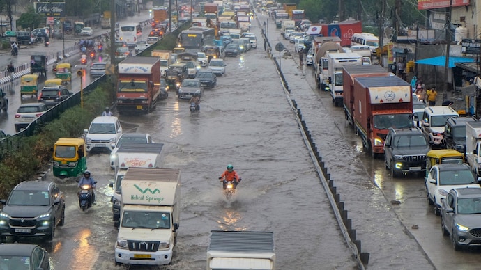
Heavy rains battered Delhi-NCR on the morning of Thursday, July 9, causing waterlogging, disruptions to general movement and commutes, and infrastructural damage.
The rain marked the first intense spell of rain Delhi-NCR has seen this monsoon season, since the weather system arrived late to Delhi on July 2.
Parts of northeast Delhi, Ghaziabad, and Noida have already recorded high levels of rain since the morning of July 8.
Mayur Vihar in Delhi recorded over 10 cm in the past 24 hours, highlighting the fury with which the rain arrived on Thursday.
But the intensity was not just because of the advancing monsoon, although it was the main driver.
Something else that arrived all the way from the Mediterranean Sea also played a key role in intensifying the downpours. A western disturbance.
HOW DID WESTERN DISTURBANCE INTENSIFY RAIN IN DELHI?
A western disturbance is a weather system that forms over the Mediterranean Sea or nearby areas and moves eastward, carrying moisture and cooler air into northern India.
The weather system often brings rain or thunderstorms and is more common in winter, though summer appearances can strongly boost monsoon activity.
According to the private weather agency Skymet, the recent heavy spells resulted from this disturbance over northern Pakistan interacting with an intense low-pressure area over central India and strong moisture-laden winds from the Arabian Sea.
The disturbance helped create a strong convergence of air masses, where different wind systems meet, pulling in extra moisture and making the atmosphere highly unstable.
This is what happened and led to thicker clouds, stronger updrafts, and heavier, more prolonged rainfall than the monsoon alone would have produced.
Previously, such rare summer western disturbances also lent a hand to the already delayed southwest monsoon to arrive in Delhi on July 2 by teaming with the monsoon trough, countering El Nino effects.
IS THERE ANY OTHER REASON?
The primary driver remains the active southwest monsoon, powered by a well-marked low-pressure area over the northwest Bay of Bengal.
This system pulled huge amounts of moisture inland, making rains widespread across northern and central India. The monsoon trough's position added to the intensity, while urban issues like poor drainage worsened flooding.
Experts say these combined systems explain the extreme short-burst rainfall in places.
The Indian Meteorological Department (IMD) has issued alerts for more showers, though the intensity of the downpours may ease soon.
Meanwhile, the weather agency has advised residents to stay indoors during heavy spells, avoid waterlogged roads, and check weather updates.
Heavy rains battered Delhi-NCR on the morning of Thursday, July 9, causing waterlogging, disruptions to general movement and commutes, and infrastructural damage.
The rain marked the first intense spell of rain Delhi-NCR has seen this monsoon season, since the weather system arrived late to Delhi on July 2.
Parts of northeast Delhi, Ghaziabad, and Noida have already recorded high levels of rain since the morning of July 8.
Mayur Vihar in Delhi recorded over 10 cm in the past 24 hours, highlighting the fury with which the rain arrived on Thursday.
But the intensity was not just because of the advancing monsoon, although it was the main driver.
Something else that arrived all the way from the Mediterranean Sea also played a key role in intensifying the downpours. A western disturbance.
HOW DID WESTERN DISTURBANCE INTENSIFY RAIN IN DELHI?
A western disturbance is a weather system that forms over the Mediterranean Sea or nearby areas and moves eastward, carrying moisture and cooler air into northern India.
The weather system often brings rain or thunderstorms and is more common in winter, though summer appearances can strongly boost monsoon activity.
According to the private weather agency Skymet, the recent heavy spells resulted from this disturbance over northern Pakistan interacting with an intense low-pressure area over central India and strong moisture-laden winds from the Arabian Sea.
The disturbance helped create a strong convergence of air masses, where different wind systems meet, pulling in extra moisture and making the atmosphere highly unstable.
This is what happened and led to thicker clouds, stronger updrafts, and heavier, more prolonged rainfall than the monsoon alone would have produced.
Previously, such rare summer western disturbances also lent a hand to the already delayed southwest monsoon to arrive in Delhi on July 2 by teaming with the monsoon trough, countering El Nino effects.
IS THERE ANY OTHER REASON?
The primary driver remains the active southwest monsoon, powered by a well-marked low-pressure area over the northwest Bay of Bengal.
This system pulled huge amounts of moisture inland, making rains widespread across northern and central India. The monsoon trough's position added to the intensity, while urban issues like poor drainage worsened flooding.
Experts say these combined systems explain the extreme short-burst rainfall in places.
The Indian Meteorological Department (IMD) has issued alerts for more showers, though the intensity of the downpours may ease soon.
Meanwhile, the weather agency has advised residents to stay indoors during heavy spells, avoid waterlogged roads, and check weather updates.

