India's rain deficit dipped from 40% to 14%, but monsoon is set to get dry again
Recent downpours have improved the country's seasonal rainfall outlook, but the monsoon is entering another phase of change. As it shifts, some regions are set to receive more rain while others could once again be left waiting.
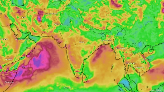
India's southwest monsoon has now covered the entire country, but its progress has been far from uniform.
While the rain-bearing system has completed its seasonal advance, rainfall remains below normal in several regions. According to the India Meteorological Department (IMD), India has recorded a 14 per cent rainfall deficit between June 1 and July 9, 2026.
However, widespread showers over the past week have significantly narrowed the shortfall from nearly 40 per cent at the end of June, offering much-needed relief to drought-hit areas.
“From June 1 up to July 9, India has recorded 14 per cent less rainfall than normal," IMD scientist Shashi Kant told news agency ANI, adding that the main pockets where rainfall has remained low thus far are eastern UP, Bihar, Jharkhand, Punjab, Marathwada region of Maharashtra, Kerala and some parts of Karnataka.
HOW HAS MONSOON BEEN IN JULY?
The IMD had forecast below-normal rainfall for July, around 94 per cent of the long-period average (LPA), the usual amount based on 1971-2020 data.
July normally brings about one-third of the season’s total rain, so this shortfall matters for farming, reservoirs, and daily life.
A monsoon trough, which is a belt of low pressure that pulls in moist winds and triggers rain is now shifting slightly north, and could potentially alter the monsoon by reshaping where rain falls most.
Early July began ideally, bringing intense rain after a dry June.
Mumbai saw strong showers that quickly lifted its reservoirs from under 10 per cent to nearly 49 per cent capacity by July 9, easing water worries.
Delhi and other northern areas also faced waterlogging, traffic, disruptions, and uprooted trees from heavy showers.
Central and western India recorded excess rain in the first week of July, further helping narrow the national gap.
However, eastern and northeastern states like Bihar, Uttar Pradesh, and parts of Jharkhand still lag, with bigger local deficits affecting crops.
The uneven pattern is typical when the monsoon changes shape, remaining active in some parts while stationary in others.
WHAT'S AHEAD FOR MONSOON?
IMD scientist Kant noted that the northward-shifting trough will bring heavy to very heavy rain this week in the Indo-Gangetic plains. That means heavy showers are expected in Uttar Pradesh, Bihar, West Bengal, Sikkim and northeastern states.
Delhi should see lighter showers and drier days soon, and central and southern peninsular India may experience subdued activity in the coming week.
Though the deficit has improved, experts urge water conservation as the season progresses.
The monsoon’s changing shape highlights its unpredictable nature, bringing both relief and reminders to manage resources carefully and savour the brief rainy days one gets to witness.
India's southwest monsoon has now covered the entire country, but its progress has been far from uniform.
While the rain-bearing system has completed its seasonal advance, rainfall remains below normal in several regions. According to the India Meteorological Department (IMD), India has recorded a 14 per cent rainfall deficit between June 1 and July 9, 2026.
However, widespread showers over the past week have significantly narrowed the shortfall from nearly 40 per cent at the end of June, offering much-needed relief to drought-hit areas.
“From June 1 up to July 9, India has recorded 14 per cent less rainfall than normal," IMD scientist Shashi Kant told news agency ANI, adding that the main pockets where rainfall has remained low thus far are eastern UP, Bihar, Jharkhand, Punjab, Marathwada region of Maharashtra, Kerala and some parts of Karnataka.
HOW HAS MONSOON BEEN IN JULY?
The IMD had forecast below-normal rainfall for July, around 94 per cent of the long-period average (LPA), the usual amount based on 1971-2020 data.
July normally brings about one-third of the season’s total rain, so this shortfall matters for farming, reservoirs, and daily life.
A monsoon trough, which is a belt of low pressure that pulls in moist winds and triggers rain is now shifting slightly north, and could potentially alter the monsoon by reshaping where rain falls most.
Early July began ideally, bringing intense rain after a dry June.
Mumbai saw strong showers that quickly lifted its reservoirs from under 10 per cent to nearly 49 per cent capacity by July 9, easing water worries.
Delhi and other northern areas also faced waterlogging, traffic, disruptions, and uprooted trees from heavy showers.
Central and western India recorded excess rain in the first week of July, further helping narrow the national gap.
However, eastern and northeastern states like Bihar, Uttar Pradesh, and parts of Jharkhand still lag, with bigger local deficits affecting crops.
The uneven pattern is typical when the monsoon changes shape, remaining active in some parts while stationary in others.
WHAT'S AHEAD FOR MONSOON?
IMD scientist Kant noted that the northward-shifting trough will bring heavy to very heavy rain this week in the Indo-Gangetic plains. That means heavy showers are expected in Uttar Pradesh, Bihar, West Bengal, Sikkim and northeastern states.
Delhi should see lighter showers and drier days soon, and central and southern peninsular India may experience subdued activity in the coming week.
Though the deficit has improved, experts urge water conservation as the season progresses.
The monsoon’s changing shape highlights its unpredictable nature, bringing both relief and reminders to manage resources carefully and savour the brief rainy days one gets to witness.

