Heavy rain alert: Isro satellite spots massive cloud build-up over Uttarakhand
Fresh satellite imagery showed dense rain-bearing clouds over Uttarakhand as the IMD issued alerts for heavy rainfall. The warning covers multiple districts and raises the risk of flash floods, waterlogging and landslides.
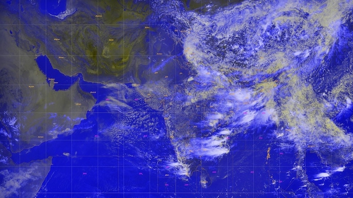
A massive blanket of rain-bearing clouds has gathered over Uttarakhand, with fresh satellite imagery showing dense convective cloud bands covering much of the Himalayan state as the India Meteorological Department (IMD) warned of heavy to very heavy rainfall on Friday, July 10.
The latest satellite images reveal thick cloud masses stretching across northern India and the western Himalayas, indicating an active monsoon system capable of producing intense spells of rain, thunderstorms and lightning over the state.
According to the IMD, light to moderate rainfall accompanied by thunderstorms is very likely at most places across Uttarakhand on July 10, with several districts expected to receive significantly heavier showers.
An orange alert has been issued for Pauri Garhwal, Nainital, Udham Singh Nagar, Champawat and Bageshwar, where heavy to very heavy rainfall is likely.
The weather office has also warned of very intense to extremely intense spells of rain, accompanied by thunderstorms and lightning, in these districts.
Meanwhile, a Watch has been issued for Dehradun, Tehri Garhwal, Haridwar, Uttarkashi, Rudraprayag, Chamoli, Almora and Pithoragarh, where isolated locations are expected to witness heavy rainfall along with thunderstorms, lightning and intense rain spells.
The IMD has advised residents in vulnerable areas, particularly those living near rivers, streams and landslide-prone slopes, to remain alert as heavy rainfall could trigger flash floods, waterlogging and slope failures in the mountainous terrain.
The wet spell is expected to continue into Saturday, July 11. The weather department forecasts light to moderate rainfall with thunderstorms at many places in the Garhwal region and at most places in the Kumaon region.
In addition, isolated heavy rainfall is likely across Uttarkashi, Rudraprayag, Chamoli, Almora, Bageshwar and Pithoragarh, where thunderstorms, lightning and intense to very intense rain spells are also expected.
The renewed burst of monsoon activity comes after moisture-laden winds strengthened over northern India, allowing deep clouds to develop rapidly over the Himalayan foothills.
Such weather systems often produce prolonged rainfall over Uttarakhand's steep terrain, increasing the risk of landslides, road blockages and swollen rivers.
Authorities have urged tourists, pilgrims undertaking the Char Dham Yatra and local residents to closely monitor official weather advisories and avoid unnecessary travel through vulnerable mountain routes during periods of heavy rainfall.
A massive blanket of rain-bearing clouds has gathered over Uttarakhand, with fresh satellite imagery showing dense convective cloud bands covering much of the Himalayan state as the India Meteorological Department (IMD) warned of heavy to very heavy rainfall on Friday, July 10.
The latest satellite images reveal thick cloud masses stretching across northern India and the western Himalayas, indicating an active monsoon system capable of producing intense spells of rain, thunderstorms and lightning over the state.
According to the IMD, light to moderate rainfall accompanied by thunderstorms is very likely at most places across Uttarakhand on July 10, with several districts expected to receive significantly heavier showers.
An orange alert has been issued for Pauri Garhwal, Nainital, Udham Singh Nagar, Champawat and Bageshwar, where heavy to very heavy rainfall is likely.
The weather office has also warned of very intense to extremely intense spells of rain, accompanied by thunderstorms and lightning, in these districts.
Meanwhile, a Watch has been issued for Dehradun, Tehri Garhwal, Haridwar, Uttarkashi, Rudraprayag, Chamoli, Almora and Pithoragarh, where isolated locations are expected to witness heavy rainfall along with thunderstorms, lightning and intense rain spells.
The IMD has advised residents in vulnerable areas, particularly those living near rivers, streams and landslide-prone slopes, to remain alert as heavy rainfall could trigger flash floods, waterlogging and slope failures in the mountainous terrain.
The wet spell is expected to continue into Saturday, July 11. The weather department forecasts light to moderate rainfall with thunderstorms at many places in the Garhwal region and at most places in the Kumaon region.
In addition, isolated heavy rainfall is likely across Uttarkashi, Rudraprayag, Chamoli, Almora, Bageshwar and Pithoragarh, where thunderstorms, lightning and intense to very intense rain spells are also expected.
The renewed burst of monsoon activity comes after moisture-laden winds strengthened over northern India, allowing deep clouds to develop rapidly over the Himalayan foothills.
Such weather systems often produce prolonged rainfall over Uttarakhand's steep terrain, increasing the risk of landslides, road blockages and swollen rivers.
Authorities have urged tourists, pilgrims undertaking the Char Dham Yatra and local residents to closely monitor official weather advisories and avoid unnecessary travel through vulnerable mountain routes during periods of heavy rainfall.

