Monsoon warming up in Bay of Bengal after power nap. When will it rain?
Something brewing in the Bay of Bengal is expected to revive the monsoon in coming days, bringing widespread rain to several states. Read when rain will arrive and where.
After a recent dry spell that left many Indians facing rising, humid heat and discomfort, signs of relief are emerging from the Bay of Bengal.
A fresh weather system is breathing new life into the southwest monsoon, promising wider rainfall across large parts of the country starting this weekend.
Meteorologists are pointing to a low-pressure area developing over eastern India, a setup that is slowly pulling in moist winds from the Bay of Bengal and Arabian Sea, which should help revive the rains.
WHAT IS HAPPENING IN THE BAY OF BENGAL?
The Bay of Bengal, that often fuels monsoon activity, is hosting a recently arrived low-pressure area.
A low-pressure area is simply a zone where air rises, drawing in moist sea winds that form clouds and rain.
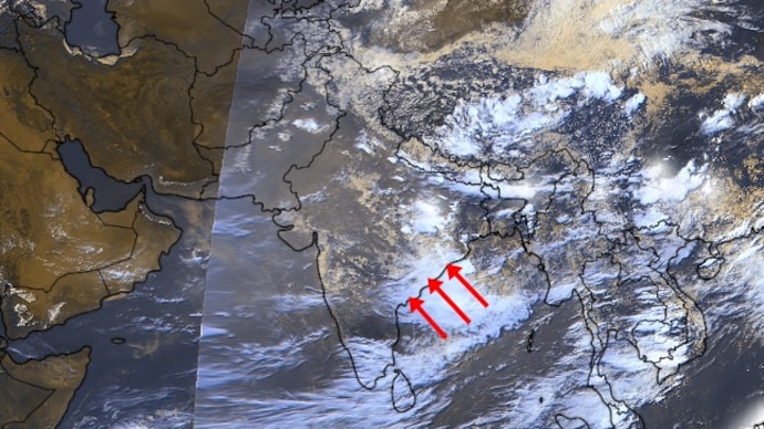
Satellite images currently show thick clouds and strong upward air movement there now, with the system strengthening and warming up to pull the monsoon back towards India.
The system is slowly moving west, and is expected to shift toward Odisha and further into West Bengal in the next 2-3 days, bringing rain first in the east before showers arrive in north and central India.
WHEN WILL IT RAIN AND WHERE?
A healthy spell of rain is likely to pick up from July 19-20, 2026, with effects building into next week.
Fairly widespread showers and some heavy spells should sweep across Punjab, Haryana, Delhi, Uttar Pradesh, Bihar, Jharkhand, Odisha, Chhattisgarh, and West Bengal, bringing welcome relief to the northern and eastern plains.
The Himalayan foothills in Uttarakhand, Himachal Pradesh, and Jammu could see very heavy bursts, so residents there should stay alert.
Farther west and south, the change will feel more gradual.
Scattered rains will begin in Rajasthan, Madhya Pradesh, Gujarat, Maharashtra, and Telangana, while the west coast sees isolated showers that grow stronger over the weekend.
After July 20, daily rainfall should edge closer to normal levels across many areas, though a massive surge isn't expected right away.
AN ESSENTIAL REVIVAL
India's monsoon is vital, and this season has also been equally uneven.
The proof of the uneven, delayed rainfall can be seen in the many major reservoirs across the country, especially in southern and eastern states, that are currently running well below normal and below last year's levels.
This revived rainfall could provide a much-needed boost to water storage, helping refill dams that support irrigation, drinking water supply, and hydropower.
The new system should help address shortfalls in eastern and central areas while bringing much-needed relief from high temperatures.
This revival offers hope after the recent pause, but balanced rainfall across regions remains key for a good season overall.
After a recent dry spell that left many Indians facing rising, humid heat and discomfort, signs of relief are emerging from the Bay of Bengal.
A fresh weather system is breathing new life into the southwest monsoon, promising wider rainfall across large parts of the country starting this weekend.
Meteorologists are pointing to a low-pressure area developing over eastern India, a setup that is slowly pulling in moist winds from the Bay of Bengal and Arabian Sea, which should help revive the rains.
WHAT IS HAPPENING IN THE BAY OF BENGAL?
The Bay of Bengal, that often fuels monsoon activity, is hosting a recently arrived low-pressure area.
A low-pressure area is simply a zone where air rises, drawing in moist sea winds that form clouds and rain.
Satellite images currently show thick clouds and strong upward air movement there now, with the system strengthening and warming up to pull the monsoon back towards India.
The system is slowly moving west, and is expected to shift toward Odisha and further into West Bengal in the next 2-3 days, bringing rain first in the east before showers arrive in north and central India.
WHEN WILL IT RAIN AND WHERE?
A healthy spell of rain is likely to pick up from July 19-20, 2026, with effects building into next week.
Fairly widespread showers and some heavy spells should sweep across Punjab, Haryana, Delhi, Uttar Pradesh, Bihar, Jharkhand, Odisha, Chhattisgarh, and West Bengal, bringing welcome relief to the northern and eastern plains.
The Himalayan foothills in Uttarakhand, Himachal Pradesh, and Jammu could see very heavy bursts, so residents there should stay alert.
Farther west and south, the change will feel more gradual.
Scattered rains will begin in Rajasthan, Madhya Pradesh, Gujarat, Maharashtra, and Telangana, while the west coast sees isolated showers that grow stronger over the weekend.
After July 20, daily rainfall should edge closer to normal levels across many areas, though a massive surge isn't expected right away.
AN ESSENTIAL REVIVAL
India's monsoon is vital, and this season has also been equally uneven.
The proof of the uneven, delayed rainfall can be seen in the many major reservoirs across the country, especially in southern and eastern states, that are currently running well below normal and below last year's levels.
This revived rainfall could provide a much-needed boost to water storage, helping refill dams that support irrigation, drinking water supply, and hydropower.
The new system should help address shortfalls in eastern and central areas while bringing much-needed relief from high temperatures.
This revival offers hope after the recent pause, but balanced rainfall across regions remains key for a good season overall.

