Google shuts Google Earth AI tool within hours after users flood internet with disturbing fake scenes
Google recently brought a new AI feature on Google Earth allowing you to use Gemini to create and modify satellite images. Within hours, the internet was flooded with bomb craters in Gaza, plane crashes, and even a nuclear power plant in Iran. Google has since pulled the feature.
Google gave users the power to change how the world looks with AI on Google Earth, and it went just as you would have expected – full of disaster. On Thursday, Google brought Nano Banana 2 to Google Earth, letting users create and modify satellite images. While Google pitched it as a way to reimagine the world, or to bring history back to life, the internet, as it always does, had a different take. Within hours, there were bombs dropping around the world, floods happening, and even Iran getting a nuclear power plant.
You see, this feature was available on the web version of Google Earth – a free platform that has 3D satellite imagery of the globe. With Nano Banana 2, you could add elements or change how a place looks with just a single prompt. For instance, you could turn your neighbourhood into a sci-fi city.
Craters in Gaza, nuclear plant in Iran
Now, giving the internet the power to change what the world looks like, was a bold call. Users did not think twice before making photorealistic fake scenes that may fool others online.
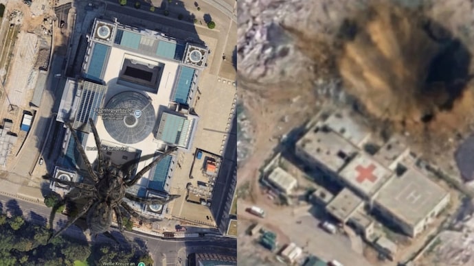
AI researcher Henk van Ess claimed that he used the tool to place a nuclear plant in Iran, along with a hospital with a bomb crater in Gaza. Both of these scenes could potentially go viral online if someone mistook it for real imagery. On top of that, Henk also showed a scene where refugees flood the US-Mexico border.
Van Ess said Google had spent 20 years building “the reference the world checks against” and had now added “a button that makes things up.”
Henk was not alone either. Since Google Earth is a free tool, anyone can create chaos by just a single prompt. For instance, some images making the rounds on social media show a plane crashing into the World Trade Centre in New York City, akin to the 9/11 attack.
Why did Google pull this feature?
Google Earth is an important tool for researchers. It allows you to look at satellite imagery across the world, and compare it to older images. For example, it can visualise the progress made when it comes to urban development of a city in the past 20 years. The tool is also used for open-source intelligence or OSINT.
But if people started flooding the internet with fake scenes, particularly of sensitive places, it may wreak havoc online. Misinformation can spread quite quickly on the internet. While Google did assure users that the AI images would be verifiable by SynthID on Gemini, the company decided to suspend it for now.
“We know that people uniquely trust Google Earth for a reliable view of the world. We’ve seen geospatial professionals using this feature for a range of useful purposes, however we’ve also seen people sharing screenshots of generated imagery that appear to violate our policies,” the company issued a statement on X. “So we’re rolling back this feature in Google Earth while we work on implementing stronger guardrails. It's important to note that generated images didn’t appear in the main Google Earth experience for others to see and were watermarked as AI generated.”
While SynthID can help detect AI-generated content from Google’s models, it may make mistakes. In some cases, users found that the images created via Nano Banana on Google Earth were not detected as AI-generated by Gemini.
Google gave users the power to change how the world looks with AI on Google Earth, and it went just as you would have expected – full of disaster. On Thursday, Google brought Nano Banana 2 to Google Earth, letting users create and modify satellite images. While Google pitched it as a way to reimagine the world, or to bring history back to life, the internet, as it always does, had a different take. Within hours, there were bombs dropping around the world, floods happening, and even Iran getting a nuclear power plant.
You see, this feature was available on the web version of Google Earth – a free platform that has 3D satellite imagery of the globe. With Nano Banana 2, you could add elements or change how a place looks with just a single prompt. For instance, you could turn your neighbourhood into a sci-fi city.
Craters in Gaza, nuclear plant in Iran
Now, giving the internet the power to change what the world looks like, was a bold call. Users did not think twice before making photorealistic fake scenes that may fool others online.
AI researcher Henk van Ess claimed that he used the tool to place a nuclear plant in Iran, along with a hospital with a bomb crater in Gaza. Both of these scenes could potentially go viral online if someone mistook it for real imagery. On top of that, Henk also showed a scene where refugees flood the US-Mexico border.
Van Ess said Google had spent 20 years building “the reference the world checks against” and had now added “a button that makes things up.”
Henk was not alone either. Since Google Earth is a free tool, anyone can create chaos by just a single prompt. For instance, some images making the rounds on social media show a plane crashing into the World Trade Centre in New York City, akin to the 9/11 attack.
Why did Google pull this feature?
Google Earth is an important tool for researchers. It allows you to look at satellite imagery across the world, and compare it to older images. For example, it can visualise the progress made when it comes to urban development of a city in the past 20 years. The tool is also used for open-source intelligence or OSINT.
But if people started flooding the internet with fake scenes, particularly of sensitive places, it may wreak havoc online. Misinformation can spread quite quickly on the internet. While Google did assure users that the AI images would be verifiable by SynthID on Gemini, the company decided to suspend it for now.
“We know that people uniquely trust Google Earth for a reliable view of the world. We’ve seen geospatial professionals using this feature for a range of useful purposes, however we’ve also seen people sharing screenshots of generated imagery that appear to violate our policies,” the company issued a statement on X. “So we’re rolling back this feature in Google Earth while we work on implementing stronger guardrails. It's important to note that generated images didn’t appear in the main Google Earth experience for others to see and were watermarked as AI generated.”
While SynthID can help detect AI-generated content from Google’s models, it may make mistakes. In some cases, users found that the images created via Nano Banana on Google Earth were not detected as AI-generated by Gemini.
Google gave users the power to change how the world looks with AI on Google Earth, and it went just as you would have expected – full of disaster. On Thursday, Google brought Nano Banana 2 to Google Earth, letting users create and modify satellite images. While Google pitched it as a way to reimagine the world, or to bring history back to life, the internet, as it always does, had a different take. Within hours, there were bombs dropping around the world, floods happening, and even Iran getting a nuclear power plant.
You see, this feature was available on the web version of Google Earth – a free platform that has 3D satellite imagery of the globe. With Nano Banana 2, you could add elements or change how a place looks with just a single prompt. For instance, you could turn your neighbourhood into a sci-fi city.
Craters in Gaza, nuclear plant in Iran
Now, giving the internet the power to change what the world looks like, was a bold call. Users did not think twice before making photorealistic fake scenes that may fool others online.
AI researcher Henk van Ess claimed that he used the tool to place a nuclear plant in Iran, along with a hospital with a bomb crater in Gaza. Both of these scenes could potentially go viral online if someone mistook it for real imagery. On top of that, Henk also showed a scene where refugees flood the US-Mexico border.
Van Ess said Google had spent 20 years building “the reference the world checks against” and had now added “a button that makes things up.”
Henk was not alone either. Since Google Earth is a free tool, anyone can create chaos by just a single prompt. For instance, some images making the rounds on social media show a plane crashing into the World Trade Centre in New York City, akin to the 9/11 attack.
Why did Google pull this feature?
Google Earth is an important tool for researchers. It allows you to look at satellite imagery across the world, and compare it to older images. For example, it can visualise the progress made when it comes to urban development of a city in the past 20 years. The tool is also used for open-source intelligence or OSINT.
But if people started flooding the internet with fake scenes, particularly of sensitive places, it may wreak havoc online. Misinformation can spread quite quickly on the internet. While Google did assure users that the AI images would be verifiable by SynthID on Gemini, the company decided to suspend it for now.
“We know that people uniquely trust Google Earth for a reliable view of the world. We’ve seen geospatial professionals using this feature for a range of useful purposes, however we’ve also seen people sharing screenshots of generated imagery that appear to violate our policies,” the company issued a statement on X. “So we’re rolling back this feature in Google Earth while we work on implementing stronger guardrails. It's important to note that generated images didn’t appear in the main Google Earth experience for others to see and were watermarked as AI generated.”
While SynthID can help detect AI-generated content from Google’s models, it may make mistakes. In some cases, users found that the images created via Nano Banana on Google Earth were not detected as AI-generated by Gemini.

