
Heavy rain drowns Andhra as deep depression moves in with 75 kmph gusty winds

The deep depression has moved inland after crossing near Kalingapatnam. Here's where heavy rain is expected as the weather system gradually weakens.


The deep depression over the Bay of Bengal has crossed the coast and moved inland, but its rain threat is far from over.
The system crossed the north Andhra Pradesh coast close to southwest of Kalingapatnam on the intervening night of September 23-24, bringing winds of 55-65 kmph, with gusts up to 75 kmph.
At 5:30 am on September 24, the system was centred over north coastal Andhra Pradesh, about 50 km west of Kalingapatnam, 80 km north-northeast of Visakhapatnam and 170 km southwest of Gopalpur in Odisha, the India Meteorological Department (IMD) said.
DEEP DEPRESSION MOVES INLAND
The weather system is forecast to move northwestwards while retaining its deep depression strength for the next 12 hours, and will then turn north-northwestwards and gradually weaken over the following 24 hours.
That means the immediate concern is no longer a cyclone forming over the sea, but the rain and strong winds the system can continue to generate after moving inland.
The IMD expects the system to weaken into a depression by Thursday evening and then into a well-marked low-pressure area by the morning of September 26.
A depression was over the westcentral and adjoining northwest Bay of Bengal on September 22 and intensified into a deep depression on September 23 as it moved towards the Andhra-Odisha coast.
NO CYCLONE FOR NOW BUT HEAVY RAINS REMAIN
There is currently no indication in the latest IMD forecast as of Thursday morning that the system will strengthen into a cyclone.
Instead, the official track shows weakening from a deep depression to a depression and then a well-marked low-pressure area.
Its impact, however, is spreading well beyond the coast.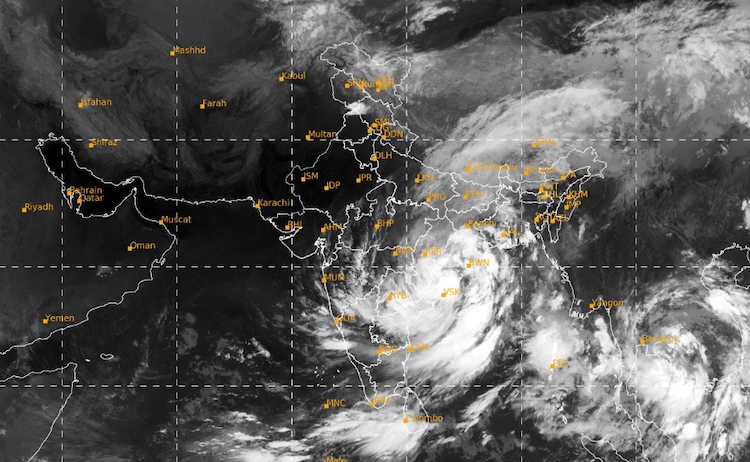
IMD has warned of heavy to very heavy rain, with isolated extremely heavy rainfall, across parts of Odisha and Andhra Pradesh on September 24.
Heavy rain is also expected in Chhattisgarh, Telangana, Jharkhand, Gangetic West Bengal and parts of Madhya Pradesh.
WHY DOES THIS DEEP DEPRESSION MATTER?
The system's weakening does not mean the weather threat ends immediately.
Intense rain can still cause waterlogging, flooding and localised flash-flood conditions, particularly where the ground is already saturated.
The IMD has flagged a low-to-moderate flash-flood threat in parts of coastal Andhra Pradesh and Odisha.
The system can still disrupt roads and railways, damage crops and vulnerable structures, and affect transport.
For the next day, therefore, the key story is how far inland the system's heavy rain extends and how quickly the weakening circulation loses its strength.