Assam floods: Satellite images show the Brahmaputra swelling threefold
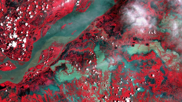
Near Jorhat, the inundated river corridor expanded to nearly 21 km, three times its earlier visible width.
At least 47 people have died as Assam’s floods deepened into one of the state’s worst emergencies in recent years. More than 7.21 lakh people across 11 districts and close to 900 villages remain affected, according to the latest report from Assam’s Disaster Reporting and Information Management System. Six deaths were recorded during the last 24 hours. Chief Minister Himanta Biswa Sarma said on Thursday that around “70 to 80 more people have been missing, and the toll is likely to increase”.
Extreme rainfall across upstream hill catchments, compounded by intense rain within Upper Assam, sent sudden surges into districts unaccustomed to flooding on this scale. Charaideo received 170 mm of rainfall, 436 per cent above normal while Golaghat recorded 147.9 mm, Jorhat 105.2 mm and Sivasagar 93.2 mm during the period analysed, as per IMD.
The result was not merely the familiar seasonal swelling of the Brahmaputra. Water entered villages, tea estates and inland settlements that residents and officials said had seen little comparable flooding in recent decades. In Upper Assam, swollen tributaries including the Dikhow, Disang and Janji carried water far beyond their usual channels.
Satellite imagery from the European Union’s Copernicus Earth-observation programme shows floodwaters spreading across the Brahmaputra valley, from Goalpara and Guwahati through Nagaon and Jorhat to eastern Assam.
Near Jorhat, the apparent inundated corridor widened to nearly 21 kilometres roughly three times its earlier visible extent as river channels merged with flooded sandbars, agricultural fields and adjoining settlements. The measurement represents the total apparent water spread along the selected transect, not the width of the Brahmaputra’s permanent channel alone.
A broader flood-extent assessment generated through the Indian Institute for Human Settlements’ Global Flood Mapper shows inundation scattered across much of the valley. The system uses Sentinel-1 radar observations, treating pre-flood imagery as a baseline and identifying anomalous water signatures in images captured during the flood. The mapped areas are indicative of flood extent and should be read alongside official bulletins.
Sivasagar remained the worst-affected district, with approximately 3.92 lakh people impacted, followed by Charaideo with 1.10 lakh and Jorhat with nearly 97,700. Floodwaters had submerged about 25,375.44 hectares of cropland, while more than 24,000 people were staying in relief camps. Nearly 1.39 lakh animals had also been affected.
The latest river-gauge data showed the Burhidihing at Chenimari–Khowang, the Dikhow at Sivasagar, the Dhansiri South at Numaligarh and the Kushiyara at Sribhumi flowing above their respective danger marks. The Disang at Nanglamuraghat was above its previous highest flood level, indicating the exceptional severity of the surge across Upper Assam.
The threat has not fully receded. The India Meteorological Department has forecast heavy rainfall, thunderstorms and lightning across Assam and Meghalaya through July 30, raising the possibility of renewed inundation in already saturated catchments
At least 47 people have died as Assam’s floods deepened into one of the state’s worst emergencies in recent years. More than 7.21 lakh people across 11 districts and close to 900 villages remain affected, according to the latest report from Assam’s Disaster Reporting and Information Management System. Six deaths were recorded during the last 24 hours. Chief Minister Himanta Biswa Sarma said on Thursday that around “70 to 80 more people have been missing, and the toll is likely to increase”.
Extreme rainfall across upstream hill catchments, compounded by intense rain within Upper Assam, sent sudden surges into districts unaccustomed to flooding on this scale. Charaideo received 170 mm of rainfall, 436 per cent above normal while Golaghat recorded 147.9 mm, Jorhat 105.2 mm and Sivasagar 93.2 mm during the period analysed, as per IMD.
The result was not merely the familiar seasonal swelling of the Brahmaputra. Water entered villages, tea estates and inland settlements that residents and officials said had seen little comparable flooding in recent decades. In Upper Assam, swollen tributaries including the Dikhow, Disang and Janji carried water far beyond their usual channels.
Satellite imagery from the European Union’s Copernicus Earth-observation programme shows floodwaters spreading across the Brahmaputra valley, from Goalpara and Guwahati through Nagaon and Jorhat to eastern Assam.
Near Jorhat, the apparent inundated corridor widened to nearly 21 kilometres roughly three times its earlier visible extent as river channels merged with flooded sandbars, agricultural fields and adjoining settlements. The measurement represents the total apparent water spread along the selected transect, not the width of the Brahmaputra’s permanent channel alone.
A broader flood-extent assessment generated through the Indian Institute for Human Settlements’ Global Flood Mapper shows inundation scattered across much of the valley. The system uses Sentinel-1 radar observations, treating pre-flood imagery as a baseline and identifying anomalous water signatures in images captured during the flood. The mapped areas are indicative of flood extent and should be read alongside official bulletins.
Sivasagar remained the worst-affected district, with approximately 3.92 lakh people impacted, followed by Charaideo with 1.10 lakh and Jorhat with nearly 97,700. Floodwaters had submerged about 25,375.44 hectares of cropland, while more than 24,000 people were staying in relief camps. Nearly 1.39 lakh animals had also been affected.
The latest river-gauge data showed the Burhidihing at Chenimari–Khowang, the Dikhow at Sivasagar, the Dhansiri South at Numaligarh and the Kushiyara at Sribhumi flowing above their respective danger marks. The Disang at Nanglamuraghat was above its previous highest flood level, indicating the exceptional severity of the surge across Upper Assam.
The threat has not fully receded. The India Meteorological Department has forecast heavy rainfall, thunderstorms and lightning across Assam and Meghalaya through July 30, raising the possibility of renewed inundation in already saturated catchments
At least 47 people have died as Assam’s floods deepened into one of the state’s worst emergencies in recent years. More than 7.21 lakh people across 11 districts and close to 900 villages remain affected, according to the latest report from Assam’s Disaster Reporting and Information Management System. Six deaths were recorded during the last 24 hours. Chief Minister Himanta Biswa Sarma said on Thursday that around “70 to 80 more people have been missing, and the toll is likely to increase”.
Extreme rainfall across upstream hill catchments, compounded by intense rain within Upper Assam, sent sudden surges into districts unaccustomed to flooding on this scale. Charaideo received 170 mm of rainfall, 436 per cent above normal while Golaghat recorded 147.9 mm, Jorhat 105.2 mm and Sivasagar 93.2 mm during the period analysed, as per IMD.
The result was not merely the familiar seasonal swelling of the Brahmaputra. Water entered villages, tea estates and inland settlements that residents and officials said had seen little comparable flooding in recent decades. In Upper Assam, swollen tributaries including the Dikhow, Disang and Janji carried water far beyond their usual channels.
Satellite imagery from the European Union’s Copernicus Earth-observation programme shows floodwaters spreading across the Brahmaputra valley, from Goalpara and Guwahati through Nagaon and Jorhat to eastern Assam.
Near Jorhat, the apparent inundated corridor widened to nearly 21 kilometres roughly three times its earlier visible extent as river channels merged with flooded sandbars, agricultural fields and adjoining settlements. The measurement represents the total apparent water spread along the selected transect, not the width of the Brahmaputra’s permanent channel alone.
A broader flood-extent assessment generated through the Indian Institute for Human Settlements’ Global Flood Mapper shows inundation scattered across much of the valley. The system uses Sentinel-1 radar observations, treating pre-flood imagery as a baseline and identifying anomalous water signatures in images captured during the flood. The mapped areas are indicative of flood extent and should be read alongside official bulletins.
Sivasagar remained the worst-affected district, with approximately 3.92 lakh people impacted, followed by Charaideo with 1.10 lakh and Jorhat with nearly 97,700. Floodwaters had submerged about 25,375.44 hectares of cropland, while more than 24,000 people were staying in relief camps. Nearly 1.39 lakh animals had also been affected.
The latest river-gauge data showed the Burhidihing at Chenimari–Khowang, the Dikhow at Sivasagar, the Dhansiri South at Numaligarh and the Kushiyara at Sribhumi flowing above their respective danger marks. The Disang at Nanglamuraghat was above its previous highest flood level, indicating the exceptional severity of the surge across Upper Assam.
The threat has not fully receded. The India Meteorological Department has forecast heavy rainfall, thunderstorms and lightning across Assam and Meghalaya through July 30, raising the possibility of renewed inundation in already saturated catchments

