Assam floods: Isro's Nisar satellite captures Brahmaputra's might from space
Nisar has captured a close-up space image of the Brahmaputra as Assam battles severe floods. The radar observations could help scientists and disaster managers track erosion, flooding and channel shifts.
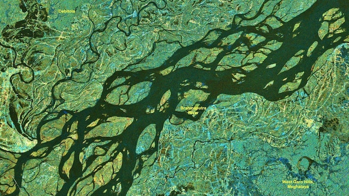
As Assam grapples with another devastating flood season, India's latest Earth observation satellite, Nisar, has captured a stunning close-up view of the mighty Brahmaputra River, revealing its vast network of braided channels, islands and floodplains from space.
The image, acquired on July 9, 2026, covers a section of the Brahmaputra near Debitala in Assam, extending towards the West Garo Hills of Meghalaya.
It showcases the river's enormous width and constantly shifting network of channels that make the Brahmaputra one of the most dynamic rivers in the world.
The dark ribbons cutting across the image represent the river's multiple water channels, while the lighter surrounding areas show floodplains, vegetation and inhabited landscapes.
The image highlights how the Brahmaputra does not flow through a single channel but spreads across a wide valley, splitting and rejoining around dozens of sandbars and river islands known as chars.
The satellite observations come as Assam continues to battle severe flooding. This year's floods have claimed 68 lives and affected more than 5.24 lakh people, with several districts remaining inundated.
Developed jointly by the Indian Space Research Organisation (Isro) and NASA, Nisar is designed to monitor changes on Earth's surface with unprecedented precision.
Unlike conventional optical satellites, its radar can image the ground through clouds and during both day and night, making it especially valuable during the monsoon when thick cloud cover limits traditional satellite observations.
The detailed imagery helps scientists map river channels, monitor erosion, identify flooded regions and track how the Brahmaputra changes course over time.
These observations are crucial because the river is constantly reshaping its banks, eroding land in one place while depositing sediment in another, making Assam one of India's most flood-prone states.
Currently in its science operations phase, Nisar is collecting observations across the globe while its data is processed by Isro's ground stations and the National Remote Sensing Centre.
For a river as powerful and unpredictable as the Brahmaputra, the satellite's regular observations offer an unprecedented view of its changing landscape, helping scientists and disaster managers better understand floods and improve future preparedness.
As Assam grapples with another devastating flood season, India's latest Earth observation satellite, Nisar, has captured a stunning close-up view of the mighty Brahmaputra River, revealing its vast network of braided channels, islands and floodplains from space.
The image, acquired on July 9, 2026, covers a section of the Brahmaputra near Debitala in Assam, extending towards the West Garo Hills of Meghalaya.
It showcases the river's enormous width and constantly shifting network of channels that make the Brahmaputra one of the most dynamic rivers in the world.
The dark ribbons cutting across the image represent the river's multiple water channels, while the lighter surrounding areas show floodplains, vegetation and inhabited landscapes.
The image highlights how the Brahmaputra does not flow through a single channel but spreads across a wide valley, splitting and rejoining around dozens of sandbars and river islands known as chars.
The satellite observations come as Assam continues to battle severe flooding. This year's floods have claimed 68 lives and affected more than 5.24 lakh people, with several districts remaining inundated.
Developed jointly by the Indian Space Research Organisation (Isro) and NASA, Nisar is designed to monitor changes on Earth's surface with unprecedented precision.
Unlike conventional optical satellites, its radar can image the ground through clouds and during both day and night, making it especially valuable during the monsoon when thick cloud cover limits traditional satellite observations.
The detailed imagery helps scientists map river channels, monitor erosion, identify flooded regions and track how the Brahmaputra changes course over time.
These observations are crucial because the river is constantly reshaping its banks, eroding land in one place while depositing sediment in another, making Assam one of India's most flood-prone states.
Currently in its science operations phase, Nisar is collecting observations across the globe while its data is processed by Isro's ground stations and the National Remote Sensing Centre.
For a river as powerful and unpredictable as the Brahmaputra, the satellite's regular observations offer an unprecedented view of its changing landscape, helping scientists and disaster managers better understand floods and improve future preparedness.
As Assam grapples with another devastating flood season, India's latest Earth observation satellite, Nisar, has captured a stunning close-up view of the mighty Brahmaputra River, revealing its vast network of braided channels, islands and floodplains from space.
The image, acquired on July 9, 2026, covers a section of the Brahmaputra near Debitala in Assam, extending towards the West Garo Hills of Meghalaya.
It showcases the river's enormous width and constantly shifting network of channels that make the Brahmaputra one of the most dynamic rivers in the world.
The dark ribbons cutting across the image represent the river's multiple water channels, while the lighter surrounding areas show floodplains, vegetation and inhabited landscapes.
The image highlights how the Brahmaputra does not flow through a single channel but spreads across a wide valley, splitting and rejoining around dozens of sandbars and river islands known as chars.
The satellite observations come as Assam continues to battle severe flooding. This year's floods have claimed 68 lives and affected more than 5.24 lakh people, with several districts remaining inundated.
Developed jointly by the Indian Space Research Organisation (Isro) and NASA, Nisar is designed to monitor changes on Earth's surface with unprecedented precision.
Unlike conventional optical satellites, its radar can image the ground through clouds and during both day and night, making it especially valuable during the monsoon when thick cloud cover limits traditional satellite observations.
The detailed imagery helps scientists map river channels, monitor erosion, identify flooded regions and track how the Brahmaputra changes course over time.
These observations are crucial because the river is constantly reshaping its banks, eroding land in one place while depositing sediment in another, making Assam one of India's most flood-prone states.
Currently in its science operations phase, Nisar is collecting observations across the globe while its data is processed by Isro's ground stations and the National Remote Sensing Centre.
For a river as powerful and unpredictable as the Brahmaputra, the satellite's regular observations offer an unprecedented view of its changing landscape, helping scientists and disaster managers better understand floods and improve future preparedness.

