Monsoon stirring back to life: New system in Bay of Bengal to bring back rain
After days of dry weather and a slowing monsoon, a fresh weather system is offering hope that widespread rainfall could soon return across India.
After a recent lull that left many parts of India sweating under dry spells and rising heat, good news is on the horizon.
A weather system that formed in the Pacific Ocean has reached the Bay of Bengal and is expected to bring monsoon rains back to India in the coming days.
HOPE ARRIVES IN BAY OF BENGAL
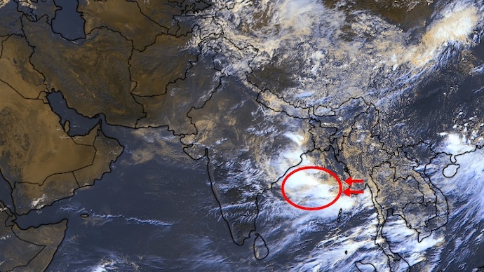
This weather circulation is inducing strong upward air movement and thick clouds over the Bay of Bengal.
Such activity often leads to the formation of a low-pressure area, a weather condition where air rises, pulling in moist winds from the sea and creating widespread clouds and rainfall.
This system is expected to gradually shift toward Odisha and West Bengal over the next 2-3 days, and should bring increased showers to east India, with effects likely reaching central and north India in the following weeks.
Satellite images show extensive cloud cover already developing, highlighting the potential for renewed monsoon activity.
UNEVEN MONSOON CONTINUES
What's more important is the system's timing as India deals with an uneven monsoon season.
India saw strong early July rains in several areas, including heavy downpours in western cities. However, a pause set in by mid-month, leaving many regions with below-average rainfall and clearer skies.
This break allowed temperatures to rise noticeably, adding to discomfort during what is normally a wetter period.
The lull also worsened the slowly recovering rain deficit, sending the rain levels back to below-normal.
The uneven season has also had an acute effect on the kharif crops across the country, as the sowing of numerous staple crops has slowed down.
The monsoon break we are experiencing is actually part of normal monsoon behaviour, but it highlights how uneven this season’s rains have been so far.
The good news is the arrival of this new system that will boost rainfall over eastern and central parts, helping address deficits in those regions, and lower temperatures.
The monsoon appears to be stirring again, and rains are expected to arrive soon.
After a recent lull that left many parts of India sweating under dry spells and rising heat, good news is on the horizon.
A weather system that formed in the Pacific Ocean has reached the Bay of Bengal and is expected to bring monsoon rains back to India in the coming days.
HOPE ARRIVES IN BAY OF BENGAL
This weather circulation is inducing strong upward air movement and thick clouds over the Bay of Bengal.
Such activity often leads to the formation of a low-pressure area, a weather condition where air rises, pulling in moist winds from the sea and creating widespread clouds and rainfall.
This system is expected to gradually shift toward Odisha and West Bengal over the next 2-3 days, and should bring increased showers to east India, with effects likely reaching central and north India in the following weeks.
Satellite images show extensive cloud cover already developing, highlighting the potential for renewed monsoon activity.
UNEVEN MONSOON CONTINUES
What's more important is the system's timing as India deals with an uneven monsoon season.
India saw strong early July rains in several areas, including heavy downpours in western cities. However, a pause set in by mid-month, leaving many regions with below-average rainfall and clearer skies.
This break allowed temperatures to rise noticeably, adding to discomfort during what is normally a wetter period.
The lull also worsened the slowly recovering rain deficit, sending the rain levels back to below-normal.
The uneven season has also had an acute effect on the kharif crops across the country, as the sowing of numerous staple crops has slowed down.
The monsoon break we are experiencing is actually part of normal monsoon behaviour, but it highlights how uneven this season’s rains have been so far.
The good news is the arrival of this new system that will boost rainfall over eastern and central parts, helping address deficits in those regions, and lower temperatures.
The monsoon appears to be stirring again, and rains are expected to arrive soon.

