Japan hit by M7.1 earthquake, tsunami alert issued: What shook beneath the surface?
A powerful magnitude 7.1 earthquake has struck Kumamoto in Kyushu, southern Japan, triggering a tsunami warning on July 28. Here is the science of what caused it, which tectonic plates were involved, and why the ground shook so violently.
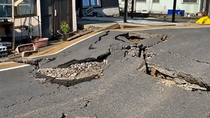
The ground in southern Japan heaved violently on the afternoon of Tuesday, July 28, and within moments, a tsunami warning was racing along the coast.
A powerful earthquake, preliminary magnitude 7.1, had struck Kumamoto on the island of Kyushu, and Japan's weather agency recorded the fiercest shaking its scale can record.
Here is the science of what happened, and what shifted deep below.
WHERE DID THE EARTHQUAKE IN JAPAN HIT TODAY?
The epicentre, the point on the surface directly above where the rupture began, lay near the cities of Uki and Uto in Kumamoto Prefecture, at a shallow depth of only about 10 kilometres.
Magnitude measures the energy an earthquake releases. Japan also uses its own shindo scale, which measures how hard the ground actually shakes in one spot, and today it hit shindo 7, the top of the scale, at which standing upright is impossible and buildings can collapse.
WHICH TECTONIC PLATES MOVED DURING THE JAPAN EARTHQUAKE?
Here lies a common misunderstanding. This was not the ocean floor diving under Japan. It was a crustal earthquake, one that ruptures inside the land itself along a crack in the rock called an active fault.
The likely culprit is the Futagawa-Hinagu fault zone, the same system that devastated Kumamoto in April 2016.
Along it, two blocks of the same continental plate grind sideways past each other, a motion scientists call strike-slip.
A satellite study of the 2016 rupture measured underground slip of up to 5.6 metres. Confirmation of today's exact mechanism is awaited from seismologists.
WHY DOES KYUSHU IN JAPAN HAVE SO MANY EARTHQUAKES?
Central Kyushu is quietly being pulled apart. It sits on a stretching belt of crust known as the Beppu-Shimabara graben, laced with volcanoes such as Aso.
Two forces do the tearing. Offshore, the Philippine Sea Plate, a slab of ocean floor, slides beneath Japan at about 4 to 5 centimetres a year, and because it pushes in at a slant, it twists the land.
Meanwhile, a rift to the southwest, the Okinawa Trough, is slowly opening.
Research using GPS confirms the crust here is being stretched, loading the faults until they snap.
WHY WAS A TSUNAMI WARNING ISSUED IN JAPAN?
Sideways-moving faults rarely make big waves, because a tsunami needs the seabed to lift vertically.
But this rupture struck at the narrow neck between the shallow Ariake and Yatsushiro seas, and even a small vertical nudge of that seabed can shove enough water to raise a modest wave.
The warning was for a wave of around one metre, not an ocean-crossing giant.
IS THIS THE SAME AS THE 2011 JAPAN EARTHQUAKE?
No. The catastrophic Tohoku earthquake of March 2011 was a megathrust, where the Pacific Plate lurched beneath northeast Japan far out at sea.
Tuesday’s quake was shallow, inland and on a wholly different fault, driven by a different plate. Same country, same Ring of Fire, entirely different machinery beneath.
The ground in southern Japan heaved violently on the afternoon of Tuesday, July 28, and within moments, a tsunami warning was racing along the coast.
A powerful earthquake, preliminary magnitude 7.1, had struck Kumamoto on the island of Kyushu, and Japan's weather agency recorded the fiercest shaking its scale can record.
Here is the science of what happened, and what shifted deep below.
WHERE DID THE EARTHQUAKE IN JAPAN HIT TODAY?
The epicentre, the point on the surface directly above where the rupture began, lay near the cities of Uki and Uto in Kumamoto Prefecture, at a shallow depth of only about 10 kilometres.
Magnitude measures the energy an earthquake releases. Japan also uses its own shindo scale, which measures how hard the ground actually shakes in one spot, and today it hit shindo 7, the top of the scale, at which standing upright is impossible and buildings can collapse.
WHICH TECTONIC PLATES MOVED DURING THE JAPAN EARTHQUAKE?
Here lies a common misunderstanding. This was not the ocean floor diving under Japan. It was a crustal earthquake, one that ruptures inside the land itself along a crack in the rock called an active fault.
The likely culprit is the Futagawa-Hinagu fault zone, the same system that devastated Kumamoto in April 2016.
Along it, two blocks of the same continental plate grind sideways past each other, a motion scientists call strike-slip.
A satellite study of the 2016 rupture measured underground slip of up to 5.6 metres. Confirmation of today's exact mechanism is awaited from seismologists.
WHY DOES KYUSHU IN JAPAN HAVE SO MANY EARTHQUAKES?
Central Kyushu is quietly being pulled apart. It sits on a stretching belt of crust known as the Beppu-Shimabara graben, laced with volcanoes such as Aso.
Two forces do the tearing. Offshore, the Philippine Sea Plate, a slab of ocean floor, slides beneath Japan at about 4 to 5 centimetres a year, and because it pushes in at a slant, it twists the land.
Meanwhile, a rift to the southwest, the Okinawa Trough, is slowly opening.
Research using GPS confirms the crust here is being stretched, loading the faults until they snap.
WHY WAS A TSUNAMI WARNING ISSUED IN JAPAN?
Sideways-moving faults rarely make big waves, because a tsunami needs the seabed to lift vertically.
But this rupture struck at the narrow neck between the shallow Ariake and Yatsushiro seas, and even a small vertical nudge of that seabed can shove enough water to raise a modest wave.
The warning was for a wave of around one metre, not an ocean-crossing giant.
IS THIS THE SAME AS THE 2011 JAPAN EARTHQUAKE?
No. The catastrophic Tohoku earthquake of March 2011 was a megathrust, where the Pacific Plate lurched beneath northeast Japan far out at sea.
Tuesday’s quake was shallow, inland and on a wholly different fault, driven by a different plate. Same country, same Ring of Fire, entirely different machinery beneath.
The ground in southern Japan heaved violently on the afternoon of Tuesday, July 28, and within moments, a tsunami warning was racing along the coast.
A powerful earthquake, preliminary magnitude 7.1, had struck Kumamoto on the island of Kyushu, and Japan's weather agency recorded the fiercest shaking its scale can record.
Here is the science of what happened, and what shifted deep below.
WHERE DID THE EARTHQUAKE IN JAPAN HIT TODAY?
The epicentre, the point on the surface directly above where the rupture began, lay near the cities of Uki and Uto in Kumamoto Prefecture, at a shallow depth of only about 10 kilometres.
Magnitude measures the energy an earthquake releases. Japan also uses its own shindo scale, which measures how hard the ground actually shakes in one spot, and today it hit shindo 7, the top of the scale, at which standing upright is impossible and buildings can collapse.
WHICH TECTONIC PLATES MOVED DURING THE JAPAN EARTHQUAKE?
Here lies a common misunderstanding. This was not the ocean floor diving under Japan. It was a crustal earthquake, one that ruptures inside the land itself along a crack in the rock called an active fault.
The likely culprit is the Futagawa-Hinagu fault zone, the same system that devastated Kumamoto in April 2016.
Along it, two blocks of the same continental plate grind sideways past each other, a motion scientists call strike-slip.
A satellite study of the 2016 rupture measured underground slip of up to 5.6 metres. Confirmation of today's exact mechanism is awaited from seismologists.
WHY DOES KYUSHU IN JAPAN HAVE SO MANY EARTHQUAKES?
Central Kyushu is quietly being pulled apart. It sits on a stretching belt of crust known as the Beppu-Shimabara graben, laced with volcanoes such as Aso.
Two forces do the tearing. Offshore, the Philippine Sea Plate, a slab of ocean floor, slides beneath Japan at about 4 to 5 centimetres a year, and because it pushes in at a slant, it twists the land.
Meanwhile, a rift to the southwest, the Okinawa Trough, is slowly opening.
Research using GPS confirms the crust here is being stretched, loading the faults until they snap.
WHY WAS A TSUNAMI WARNING ISSUED IN JAPAN?
Sideways-moving faults rarely make big waves, because a tsunami needs the seabed to lift vertically.
But this rupture struck at the narrow neck between the shallow Ariake and Yatsushiro seas, and even a small vertical nudge of that seabed can shove enough water to raise a modest wave.
The warning was for a wave of around one metre, not an ocean-crossing giant.
IS THIS THE SAME AS THE 2011 JAPAN EARTHQUAKE?
No. The catastrophic Tohoku earthquake of March 2011 was a megathrust, where the Pacific Plate lurched beneath northeast Japan far out at sea.
Tuesday’s quake was shallow, inland and on a wholly different fault, driven by a different plate. Same country, same Ring of Fire, entirely different machinery beneath.

