5 systems over Bay of Bengal, Arabian Sea revive monsoon rain, Isro images show
Isro's INSAT-3DR and INSAT-3DS satellites have captured five cyclonic circulations over the Bay of Bengal and Arabian Sea feeding an active monsoon trough, bringing rain back to Delhi and central India. Here is what the images show and why the science works.
Delhi and the plains of northern India spent last week under a dry, sulky sky. This week, the sky changed its mind.
Rain has returned to swathes of the country, from the hills of Uttarakhand to the coast of Odisha, and the reason lies in a piece of weather machinery that meteorologists have been watching build for days: a cluster of spinning air pockets working together with the monsoon's main highway, the monsoon trough.
Fresh images from Isro's INSAT-3DR and INSAT-3DS satellites, captured on the morning of July 22, show exactly how this system looks from space.
WHAT IS A CYCLONIC CIRCULATION, AND WHY DOES IT MATTER FOR RAIN?
A cyclonic circulation is a pocket of swirling wind around a patch of lower air pressure, spinning anticlockwise in the Northern Hemisphere.
It is a smaller, gentler cousin of a cyclone, and it does not need a name or a warning bulletin, but it does the same basic job: it pulls in moist air, forces it to rise, and helps it cool into clouds.
According to the India Meteorological Department (IMD), five such circulations are currently feeding the monsoon, sitting over Haryana, northeast Madhya Pradesh, southwest Rajasthan, north Chhattisgarh and the west-central Bay of Bengal.
A trough also links the Bay of Bengal circulation onward to the northeast Arabian Sea, effectively wiring both seas into a single rain engine over the north and west of the country.
WHAT IS THE MONSOON TROUGH, AND HOW DOES IT WORK WITH THESE CIRCULATIONS?
The monsoon trough is a long, low-pressure belt that runs across the country through the peak monsoon months, roughly from Rajasthan in the northwest down towards the Bay of Bengal in the southeast.
Think of it as the monsoon's main road. Rain-bearing systems tend to travel along it, and wherever it sits is usually where the heaviest, most persistent rain falls.
With five circulations sitting along or near this line, air converges from multiple directions at once, forcing warm, moist air upward until it cools, condenses and builds into towering rain clouds.
WHAT DO ISRO'S SATELLITE IMAGES SHOW OVER INDIA RIGHT NOW?
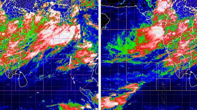
The clearest picture comes from INSAT-3DR's infrared imagery taken on July 22.
On the India sector image, the IMD marks the Bay of Bengal in named zones, the northwest bay, northeast bay, west-central bay and so on, and the coldest, whitest cloud tops sit squarely in the northwest and northeast bay zones, spilling across Odisha, West Bengal, Jharkhand and Bihar.
That white and pale-pink colouring marks cloud tops at roughly minus 50 to minus 70 degrees Celsius or colder, the signature of deep, vigorous convection rather than ordinary low cloud.
A second band of red and green, slightly warmer but still high cloud, drapes diagonally across central India towards the west coast.
The companion image, centred on the Arabian Sea, shows a similar story on the other flank.
The strongest cold-cloud mass sits over the east-central Arabian Sea, pressing into the Gujarat and Maharashtra coastline, while the rest of the sea towards Oman and Somalia stays largely clear.
This is consistent with the moisture channel that links the Bay of Bengal circulation to the northeast Arabian Sea.
IMD's separate cloud-top brightness temperature product, a wider view stretching from the Arabian Sea to Southeast Asia and captured a few hours earlier, plots contour lines directly onto the cloud field.
It shows several distinct cold cores scattered across central India, roughly between Gujarat and Odisha, with contours reaching into the minus 60 to minus 80 degree range at their coldest points, each one a separate pocket of intense convection rather than one uniform blanket of cloud.
Nighttime imagery from the newer INSAT-3DS satellite, taken a few hours after midnight on July 22, tells the same story in a different light.
Its thermal picture shows a distinct diagonal band of bright, cold clouds running from the Arabian Sea across Gujarat, Madhya Pradesh and Chhattisgarh towards the Bay of Bengal and Bangladesh, a visual trace of the monsoon trough itself.
The matching water vapour image, which tracks moisture higher up in the atmosphere rather than at the cloud tops, shows that same diagonal band lit up brightly, confirming that the moisture feeding this system is not just sitting near the surface but is saturating the atmosphere several kilometres up, exactly the conditions needed to keep the rain going.
WHY DID DELHI AND NORTH INDIA GET RAIN AGAIN AFTER THE DRY SPELL?
For the first ten days of July, the trough had drifted north towards the Himalayan foothills, a classic break phase that left central and northern India dry while the northeast stayed wet.
The pattern has since shifted back towards the plains, with heavy to very heavy rain forecast for Haryana, Chandigarh, Delhi, Punjab and western Uttar Pradesh, alongside continuing rain over Bihar, Jharkhand, West Bengal, Chhattisgarh, Konkan, Goa and the northeastern states.
DOES THIS ACTIVE SPELL CONTRADICT THIS YEAR'S EL NINO CONCERNS?
Not quite. El Nino, a warming of the central and eastern Pacific Ocean, tends to weaken the Indian monsoon over an entire season by nudging global wind patterns the wrong way.
But the monsoon does not rain evenly. Season-long patterns like El Nino set the background mood, while shorter, week-to-week systems like these five circulations and the trough decide what happens on a given day.
A well-organised trough feeding off five circulations can produce a genuinely active spell even in a season with a subdued broader outlook, which is precisely what the satellite images are now showing.
WHAT SHOULD PEOPLE EXPECT IN THE COMING DAYS?
IMD's outlook points to widespread rain continuing over Konkan and Goa, the western Himalayan states and the northeast, with fairly widespread activity over central India, including Chhattisgarh and both halves of Madhya Pradesh.
Isolated pockets could see heavy to very heavy falls, particularly over Gujarat and Maharashtra, so localised waterlogging and travel disruption remain a real possibility even as the rain brings welcome relief to a monsoon season that had been running behind.
Delhi and the plains of northern India spent last week under a dry, sulky sky. This week, the sky changed its mind.
Rain has returned to swathes of the country, from the hills of Uttarakhand to the coast of Odisha, and the reason lies in a piece of weather machinery that meteorologists have been watching build for days: a cluster of spinning air pockets working together with the monsoon's main highway, the monsoon trough.
Fresh images from Isro's INSAT-3DR and INSAT-3DS satellites, captured on the morning of July 22, show exactly how this system looks from space.
WHAT IS A CYCLONIC CIRCULATION, AND WHY DOES IT MATTER FOR RAIN?
A cyclonic circulation is a pocket of swirling wind around a patch of lower air pressure, spinning anticlockwise in the Northern Hemisphere.
It is a smaller, gentler cousin of a cyclone, and it does not need a name or a warning bulletin, but it does the same basic job: it pulls in moist air, forces it to rise, and helps it cool into clouds.
According to the India Meteorological Department (IMD), five such circulations are currently feeding the monsoon, sitting over Haryana, northeast Madhya Pradesh, southwest Rajasthan, north Chhattisgarh and the west-central Bay of Bengal.
A trough also links the Bay of Bengal circulation onward to the northeast Arabian Sea, effectively wiring both seas into a single rain engine over the north and west of the country.
WHAT IS THE MONSOON TROUGH, AND HOW DOES IT WORK WITH THESE CIRCULATIONS?
The monsoon trough is a long, low-pressure belt that runs across the country through the peak monsoon months, roughly from Rajasthan in the northwest down towards the Bay of Bengal in the southeast.
Think of it as the monsoon's main road. Rain-bearing systems tend to travel along it, and wherever it sits is usually where the heaviest, most persistent rain falls.
With five circulations sitting along or near this line, air converges from multiple directions at once, forcing warm, moist air upward until it cools, condenses and builds into towering rain clouds.
WHAT DO ISRO'S SATELLITE IMAGES SHOW OVER INDIA RIGHT NOW?
The clearest picture comes from INSAT-3DR's infrared imagery taken on July 22.
On the India sector image, the IMD marks the Bay of Bengal in named zones, the northwest bay, northeast bay, west-central bay and so on, and the coldest, whitest cloud tops sit squarely in the northwest and northeast bay zones, spilling across Odisha, West Bengal, Jharkhand and Bihar.
That white and pale-pink colouring marks cloud tops at roughly minus 50 to minus 70 degrees Celsius or colder, the signature of deep, vigorous convection rather than ordinary low cloud.
A second band of red and green, slightly warmer but still high cloud, drapes diagonally across central India towards the west coast.
The companion image, centred on the Arabian Sea, shows a similar story on the other flank.
The strongest cold-cloud mass sits over the east-central Arabian Sea, pressing into the Gujarat and Maharashtra coastline, while the rest of the sea towards Oman and Somalia stays largely clear.
This is consistent with the moisture channel that links the Bay of Bengal circulation to the northeast Arabian Sea.
IMD's separate cloud-top brightness temperature product, a wider view stretching from the Arabian Sea to Southeast Asia and captured a few hours earlier, plots contour lines directly onto the cloud field.
It shows several distinct cold cores scattered across central India, roughly between Gujarat and Odisha, with contours reaching into the minus 60 to minus 80 degree range at their coldest points, each one a separate pocket of intense convection rather than one uniform blanket of cloud.
Nighttime imagery from the newer INSAT-3DS satellite, taken a few hours after midnight on July 22, tells the same story in a different light.
Its thermal picture shows a distinct diagonal band of bright, cold clouds running from the Arabian Sea across Gujarat, Madhya Pradesh and Chhattisgarh towards the Bay of Bengal and Bangladesh, a visual trace of the monsoon trough itself.
The matching water vapour image, which tracks moisture higher up in the atmosphere rather than at the cloud tops, shows that same diagonal band lit up brightly, confirming that the moisture feeding this system is not just sitting near the surface but is saturating the atmosphere several kilometres up, exactly the conditions needed to keep the rain going.
WHY DID DELHI AND NORTH INDIA GET RAIN AGAIN AFTER THE DRY SPELL?
For the first ten days of July, the trough had drifted north towards the Himalayan foothills, a classic break phase that left central and northern India dry while the northeast stayed wet.
The pattern has since shifted back towards the plains, with heavy to very heavy rain forecast for Haryana, Chandigarh, Delhi, Punjab and western Uttar Pradesh, alongside continuing rain over Bihar, Jharkhand, West Bengal, Chhattisgarh, Konkan, Goa and the northeastern states.
DOES THIS ACTIVE SPELL CONTRADICT THIS YEAR'S EL NINO CONCERNS?
Not quite. El Nino, a warming of the central and eastern Pacific Ocean, tends to weaken the Indian monsoon over an entire season by nudging global wind patterns the wrong way.
But the monsoon does not rain evenly. Season-long patterns like El Nino set the background mood, while shorter, week-to-week systems like these five circulations and the trough decide what happens on a given day.
A well-organised trough feeding off five circulations can produce a genuinely active spell even in a season with a subdued broader outlook, which is precisely what the satellite images are now showing.
WHAT SHOULD PEOPLE EXPECT IN THE COMING DAYS?
IMD's outlook points to widespread rain continuing over Konkan and Goa, the western Himalayan states and the northeast, with fairly widespread activity over central India, including Chhattisgarh and both halves of Madhya Pradesh.
Isolated pockets could see heavy to very heavy falls, particularly over Gujarat and Maharashtra, so localised waterlogging and travel disruption remain a real possibility even as the rain brings welcome relief to a monsoon season that had been running behind.
Delhi and the plains of northern India spent last week under a dry, sulky sky. This week, the sky changed its mind.
Rain has returned to swathes of the country, from the hills of Uttarakhand to the coast of Odisha, and the reason lies in a piece of weather machinery that meteorologists have been watching build for days: a cluster of spinning air pockets working together with the monsoon's main highway, the monsoon trough.
Fresh images from Isro's INSAT-3DR and INSAT-3DS satellites, captured on the morning of July 22, show exactly how this system looks from space.
WHAT IS A CYCLONIC CIRCULATION, AND WHY DOES IT MATTER FOR RAIN?
A cyclonic circulation is a pocket of swirling wind around a patch of lower air pressure, spinning anticlockwise in the Northern Hemisphere.
It is a smaller, gentler cousin of a cyclone, and it does not need a name or a warning bulletin, but it does the same basic job: it pulls in moist air, forces it to rise, and helps it cool into clouds.
According to the India Meteorological Department (IMD), five such circulations are currently feeding the monsoon, sitting over Haryana, northeast Madhya Pradesh, southwest Rajasthan, north Chhattisgarh and the west-central Bay of Bengal.
A trough also links the Bay of Bengal circulation onward to the northeast Arabian Sea, effectively wiring both seas into a single rain engine over the north and west of the country.
WHAT IS THE MONSOON TROUGH, AND HOW DOES IT WORK WITH THESE CIRCULATIONS?
The monsoon trough is a long, low-pressure belt that runs across the country through the peak monsoon months, roughly from Rajasthan in the northwest down towards the Bay of Bengal in the southeast.
Think of it as the monsoon's main road. Rain-bearing systems tend to travel along it, and wherever it sits is usually where the heaviest, most persistent rain falls.
With five circulations sitting along or near this line, air converges from multiple directions at once, forcing warm, moist air upward until it cools, condenses and builds into towering rain clouds.
WHAT DO ISRO'S SATELLITE IMAGES SHOW OVER INDIA RIGHT NOW?
The clearest picture comes from INSAT-3DR's infrared imagery taken on July 22.
On the India sector image, the IMD marks the Bay of Bengal in named zones, the northwest bay, northeast bay, west-central bay and so on, and the coldest, whitest cloud tops sit squarely in the northwest and northeast bay zones, spilling across Odisha, West Bengal, Jharkhand and Bihar.
That white and pale-pink colouring marks cloud tops at roughly minus 50 to minus 70 degrees Celsius or colder, the signature of deep, vigorous convection rather than ordinary low cloud.
A second band of red and green, slightly warmer but still high cloud, drapes diagonally across central India towards the west coast.
The companion image, centred on the Arabian Sea, shows a similar story on the other flank.
The strongest cold-cloud mass sits over the east-central Arabian Sea, pressing into the Gujarat and Maharashtra coastline, while the rest of the sea towards Oman and Somalia stays largely clear.
This is consistent with the moisture channel that links the Bay of Bengal circulation to the northeast Arabian Sea.
IMD's separate cloud-top brightness temperature product, a wider view stretching from the Arabian Sea to Southeast Asia and captured a few hours earlier, plots contour lines directly onto the cloud field.
It shows several distinct cold cores scattered across central India, roughly between Gujarat and Odisha, with contours reaching into the minus 60 to minus 80 degree range at their coldest points, each one a separate pocket of intense convection rather than one uniform blanket of cloud.
Nighttime imagery from the newer INSAT-3DS satellite, taken a few hours after midnight on July 22, tells the same story in a different light.
Its thermal picture shows a distinct diagonal band of bright, cold clouds running from the Arabian Sea across Gujarat, Madhya Pradesh and Chhattisgarh towards the Bay of Bengal and Bangladesh, a visual trace of the monsoon trough itself.
The matching water vapour image, which tracks moisture higher up in the atmosphere rather than at the cloud tops, shows that same diagonal band lit up brightly, confirming that the moisture feeding this system is not just sitting near the surface but is saturating the atmosphere several kilometres up, exactly the conditions needed to keep the rain going.
WHY DID DELHI AND NORTH INDIA GET RAIN AGAIN AFTER THE DRY SPELL?
For the first ten days of July, the trough had drifted north towards the Himalayan foothills, a classic break phase that left central and northern India dry while the northeast stayed wet.
The pattern has since shifted back towards the plains, with heavy to very heavy rain forecast for Haryana, Chandigarh, Delhi, Punjab and western Uttar Pradesh, alongside continuing rain over Bihar, Jharkhand, West Bengal, Chhattisgarh, Konkan, Goa and the northeastern states.
DOES THIS ACTIVE SPELL CONTRADICT THIS YEAR'S EL NINO CONCERNS?
Not quite. El Nino, a warming of the central and eastern Pacific Ocean, tends to weaken the Indian monsoon over an entire season by nudging global wind patterns the wrong way.
But the monsoon does not rain evenly. Season-long patterns like El Nino set the background mood, while shorter, week-to-week systems like these five circulations and the trough decide what happens on a given day.
A well-organised trough feeding off five circulations can produce a genuinely active spell even in a season with a subdued broader outlook, which is precisely what the satellite images are now showing.
WHAT SHOULD PEOPLE EXPECT IN THE COMING DAYS?
IMD's outlook points to widespread rain continuing over Konkan and Goa, the western Himalayan states and the northeast, with fairly widespread activity over central India, including Chhattisgarh and both halves of Madhya Pradesh.
Isolated pockets could see heavy to very heavy falls, particularly over Gujarat and Maharashtra, so localised waterlogging and travel disruption remain a real possibility even as the rain brings welcome relief to a monsoon season that had been running behind.

